Saint-Molf geodata
Saint-Molf (Pays de la Loire) is a populated place; located in France in Europe/Paris (GMT+2) time zone. With population of 1,617 people, there are 5771 cities with bigger population in this country. Compared to other cities in France, 50.2% of cities are located further ↑North; 96.1% of cities are located further →East and 96.3% of cities have higher elevation than Saint-Molf. Note1
Administrative division(s):
- Level 1: Pays de la Loire
- Level 2: Loire-Atlantique
- Level 3: Arrondissement de Saint-Nazaire
- Level 4: Saint-Molf


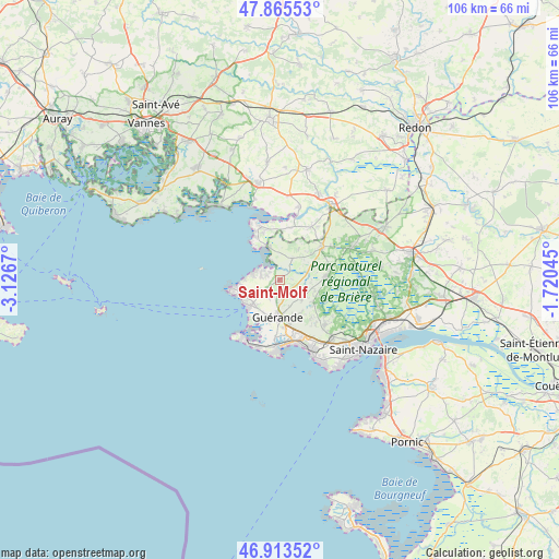
Saint-Molf GPS coordinates[2]
47° 23' 30.012" North, 2° 25' 24.852" West
| Map corner | latitude | longitude |
|---|---|---|
| Upper-left | 47.86553°, | -3.1267° |
| Center: | 47.39167°, | -2.42357° |
| Lower-right: | 46.91352°, | -1.72045° |
| Map W x H: | 105.9×105.9 km | = 65.8×65.8mi |
| max Lat: | 51.07786° ⇑50.2% North |
| Saint-Molf: | 47.39167° |
| min Lat: | ⇓49.8% South 41.3874° |
| min Long | Saint-Molf | max Long |
| -5.08615° | -2.42357° | 9.52242° |
| W 3.9%⇐ | ⇒96.1% E |
Elevation
Elevation of Saint-Molf is 13 m = 43 ft, and this is 180.7 m = 593 ft below average elevation for this country.
| Max E: |
2333 m = 7654 ft | 96.3% |
| Avg. | 193.7 m = 635 ft | |
| Saint-Molf | 13 m = 43 ft | |
Min E: |
-1 m = -3 ft | 3.7% |
See also: France elevation on elevation.city.
Geographical zone
Saint-Molf is located in North temperate zone (between Tropic of Cancer and the Arctic Circle). Distance of this North polar circle is 2131.7 km =1324.6 mi to North.| Distance of | km | miles | from Saint-Molf |
|---|---|---|---|
| North Pole | 4737.6 | 2943.8 | to North |
| Arctic Circle | 2131.7 | 1324.6 | to North |
| Tropic Cancer | 2663.5 | 1655 | to South |
| Equator | 5269.5 | 3274.3 | to South |


Nearby cities:
15 places around Saint-Molf: (largest is in red/bold)
• Assérac
4.9 km =3 mi,  32°
32°
• Batz-sur-Mer
13.4 km =8.3 mi,  198°
198°
• Camoël
10.2 km =6.3 mi,  12°
12°
• Férel
11.8 km =7.3 mi, 31°
• Guérande
7 km =4.3 mi,  182°
182°
• Herbignac
10.1 km =6.3 mi,  51°
51°
• La Baule-Escoublac
11.9 km =7.4 mi,  157°
157°
• La Turballe
8 km =5 mi,  231°
231°
• Le Croisic
13 km =8.1 mi,  211°
211°
• Le Pouliguen
13.6 km =8.5 mi, 181°
• Mesquer
2.9 km =1.8 mi,  287°
287°
• Piriac-sur-Mer
9.3 km =5.8 mi,  261°
261°
• Pénestin
10.7 km =6.6 mi,  339°
339°
• Saint-André-des-Eaux
12.1 km =7.5 mi,  135°
135°
• Saint-Lyphard
8.8 km =5.5 mi,  85°
85°
Sources, notices
• [Note1] Compared only with cities in France existing in our database
• [Src1] Map data: © OpenStreetMap contributors (CC-BY-SA)
• [Src2] Other city data from geonames.org with taken over terms of usage.
• [Src3] Geographical zone / Annual Mean Temperature by Robert A. Rohde @ Wikipedia
