Pierrevert geodata
Pierrevert (Provence-Alpes-Côte d'Azur) is a populated place; located in France in Europe/Paris (GMT+2) time zone. With population of 3,564 people, there are 2736 cities with bigger population in this country. Compared to other cities in France, 89% of cities are located further ↑North; 84.7% of cities are located further ←West and 88.3% of cities have lower elevation than Pierrevert. Note1
Administrative division(s):
- Level 1: Provence-Alpes-Côte d'Azur
- Level 2: Alpes-de-Haute-Provence
- Level 3: Arrondissement de Forcalquier
- Level 4: Pierrevert


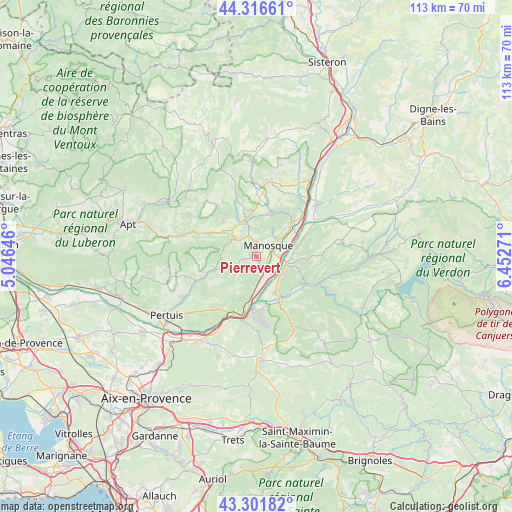
Pierrevert GPS coordinates[2]
43° 48' 40.932" North, 5° 44' 58.488" East
| Map corner | latitude | longitude |
|---|---|---|
| Upper-left | 44.31661°, | 5.04646° |
| Center: | 43.81137°, | 5.74958° |
| Lower-right: | 43.30182°, | 6.45271° |
| Map W x H: | 112.8×112.8 km | = 70.1×70.1mi |
| max Lat: | 51.07786° ⇑89% North |
| Pierrevert: | 43.81137° |
| min Lat: | ⇓11% South 41.3874° |
| min Long | Pierrevert | max Long |
| -5.08615° | 5.74958° | 9.52242° |
| W 84.7%⇐ | ⇒15.3% E |
Elevation
Elevation of Pierrevert is 394 m = 1293 ft, and this is 200.3 m = 657 ft above average elevation for this country.
| Max E: |
2333 m = 7654 ft | 11.7% |
| Pierrevert | 394 m 1293 ft | |
| Avg. | 193.7 m = 635 ft | |
Min E: |
-1 m = -3 ft | 88.3% |
See also: France elevation on elevation.city.
Geographical zone
Pierrevert is located in North temperate zone (between Tropic of Cancer and the Arctic Circle). Distance of this Northern Tropic circle is 2265.4 km =1407.7 mi to South.| Distance of | km | miles | from Pierrevert |
|---|---|---|---|
| North Pole | 5135.7 | 3191.2 | to North |
| Arctic Circle | 2529.8 | 1571.9 | to North |
| Tropic Cancer | 2265.4 | 1407.7 | to South |
| Equator | 4871.4 | 3026.9 | to South |


Nearby cities:
15 places around Pierrevert: (largest is in red/bold)
• Beaumont-de-Pertuis
9.5 km =5.9 mi,  210°
210°
• Corbières-en-Provence
5.6 km =3.5 mi,  178°
178°
• Céreste
14 km =8.7 mi,  290°
290°
• Dauphin
10 km =6.2 mi,  15°
15°
• Grambois
14 km =8.7 mi,  247°
247°
• Gréoux-les-Bains
12.3 km =7.6 mi,  118°
118°
• La Bastide-des-Jourdans
9.7 km =6 mi, 252°
• Manosque
3.6 km =2.2 mi,  57°
57°
• Reillanne
10.4 km =6.5 mi,  316°
316°
• Saint-Maime
10.9 km =6.8 mi, 18°
• Saint-Michel-l’Observatoire
11.3 km =7 mi,  346°
346°
• Sainte-Tulle
3.1 km =1.9 mi,  155°
155°
• Villeneuve
12.9 km =8 mi,  44°
44°
• Vinon-sur-Verdon
10.8 km =6.7 mi,  152°
152°
• Volx
10.4 km =6.5 mi, 44°
Sources, notices
• [Note1] Compared only with cities in France existing in our database
• [Src1] Map data: © OpenStreetMap contributors (CC-BY-SA)
• [Src2] Other city data from geonames.org with taken over terms of usage.
• [Src3] Geographical zone / Annual Mean Temperature by Robert A. Rohde @ Wikipedia
