Villeneuve geodata
Villeneuve (Provence-Alpes-Côte d'Azur) is a populated place; located in France in Europe/Paris (GMT+2) time zone. With population of 3,309 people, there are 2949 cities with bigger population in this country. Compared to other cities in France, 88.1% of cities are located further ↑North; 85.6% of cities are located further ←West and 90.3% of cities have lower elevation than Villeneuve. Note1
Administrative division(s):
- Level 1: Provence-Alpes-Côte d'Azur
- Level 2: Alpes-de-Haute-Provence
- Level 3: Arrondissement de Forcalquier
- Level 4: Villeneuve


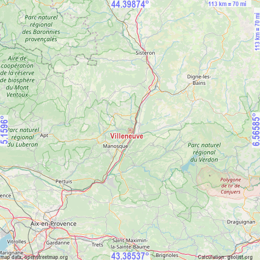
Villeneuve GPS coordinates[2]
43° 53' 39.156" North, 5° 51' 45.792" East
| Map corner | latitude | longitude |
|---|---|---|
| Upper-left | 44.39874°, | 5.1596° |
| Center: | 43.89421°, | 5.86272° |
| Lower-right: | 43.38537°, | 6.56585° |
| Map W x H: | 112.7×112.7 km | = 70×70mi |
| max Lat: | 51.07786° ⇑88.1% North |
| Villeneuve: | 43.89421° |
| min Lat: | ⇓11.9% South 41.3874° |
| min Long | Villeneuve | max Long |
| -5.08615° | 5.86272° | 9.52242° |
| W 85.6%⇐ | ⇒14.4% E |
Elevation
Elevation of Villeneuve is 434 m = 1424 ft, and this is 240.3 m = 788 ft above average elevation for this country.
| Max E: |
2333 m = 7654 ft | 9.7% |
| Villeneuve | 434 m 1424 ft | |
| Avg. | 193.7 m = 635 ft | |
Min E: |
-1 m = -3 ft | 90.3% |
See also: France elevation on elevation.city.
Geographical zone
Villeneuve is located in North temperate zone (between Tropic of Cancer and the Arctic Circle). Distance of this Northern Tropic circle is 2274.7 km =1413.4 mi to South.| Distance of | km | miles | from Villeneuve |
|---|---|---|---|
| North Pole | 5126.5 | 3185.5 | to North |
| Arctic Circle | 2520.6 | 1566.2 | to North |
| Tropic Cancer | 2274.7 | 1413.4 | to South |
| Equator | 4880.6 | 3032.7 | to South |


Nearby cities:
15 places around Villeneuve: (largest is in red/bold)
• Dauphin
6.4 km =4 mi,  273°
273°
• Forcalquier
9.8 km =6.1 mi,  317°
317°
• Gréoux-les-Bains
15.2 km =9.4 mi,  173°
173°
• La Brillanne
4.3 km =2.7 mi,  31°
31°
• Mane
9.1 km =5.7 mi,  302°
302°
• Manosque
9.5 km =5.9 mi,  219°
219°
• Oraison
5.1 km =3.2 mi,  60°
60°
• Peyruis
16.2 km =10.1 mi,  22°
22°
• Pierrerue
7.3 km =4.5 mi,  340°
340°
• Pierrevert
12.9 km =8 mi, 224°
• Saint-Maime
5.7 km =3.5 mi,  280°
280°
• Saint-Michel-l’Observatoire
11.9 km =7.4 mi, 278°
• Sainte-Tulle
14.3 km =8.9 mi,  213°
213°
• Valensole
11.6 km =7.2 mi,  122°
122°
• Volx
2.5 km =1.6 mi, 223°
Sources, notices
• [Note1] Compared only with cities in France existing in our database
• [Src1] Map data: © OpenStreetMap contributors (CC-BY-SA)
• [Src2] Other city data from geonames.org with taken over terms of usage.
• [Src3] Geographical zone / Annual Mean Temperature by Robert A. Rohde @ Wikipedia
