Sainte-Tulle geodata
Sainte-Tulle (Provence-Alpes-Côte d'Azur) is a populated place; located in France in Europe/Paris (GMT+2) time zone. With population of 3,404 people, there are 2863 cities with bigger population in this country. Compared to other cities in France, 89.3% of cities are located further ↑North; 84.8% of cities are located further ←West and 81.4% of cities have lower elevation than Sainte-Tulle. Note1
Administrative division(s):
- Level 1: Provence-Alpes-Côte d'Azur
- Level 2: Alpes-de-Haute-Provence
- Level 3: Arrondissement de Forcalquier
- Level 4: Sainte-Tulle


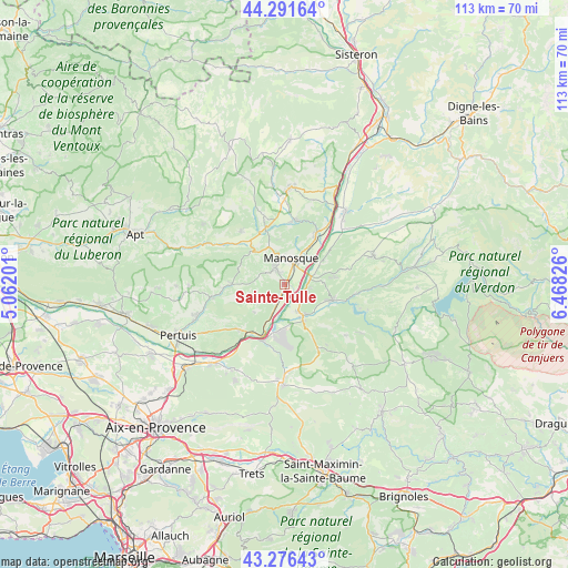
Sainte-Tulle GPS coordinates[2]
43° 47' 10.284" North, 5° 45' 54.468" East
| Map corner | latitude | longitude |
|---|---|---|
| Upper-left | 44.29164°, | 5.06201° |
| Center: | 43.78619°, | 5.76513° |
| Lower-right: | 43.27643°, | 6.46826° |
| Map W x H: | 112.9×112.9 km | = 70.2×70.2mi |
| max Lat: | 51.07786° ⇑89.3% North |
| Sainte-Tulle: | 43.78619° |
| min Lat: | ⇓10.7% South 41.3874° |
| min Long | Sainte-Tulle | max Long |
| -5.08615° | 5.76513° | 9.52242° |
| W 84.8%⇐ | ⇒15.2% E |
Elevation
Elevation of Sainte-Tulle is 304 m = 997 ft, and this is 110.3 m = 362 ft above average elevation for this country.
| Max E: |
2333 m = 7654 ft | 18.6% |
| Sainte-Tulle | 304 m 997 ft | |
| Avg. | 193.7 m = 635 ft | |
Min E: |
-1 m = -3 ft | 81.4% |
See also: France elevation on elevation.city.
Geographical zone
Sainte-Tulle is located in North temperate zone (between Tropic of Cancer and the Arctic Circle). Distance of this Northern Tropic circle is 2262.6 km =1405.9 mi to South.| Distance of | km | miles | from Sainte-Tulle |
|---|---|---|---|
| North Pole | 5138.5 | 3192.9 | to North |
| Arctic Circle | 2532.6 | 1573.7 | to North |
| Tropic Cancer | 2262.6 | 1405.9 | to South |
| Equator | 4868.6 | 3025.2 | to South |


Nearby cities:
15 places around Sainte-Tulle: (largest is in red/bold)
• Beaumont-de-Pertuis
8.1 km =5 mi,  228°
228°
• Corbières-en-Provence
3 km =1.9 mi,  201°
201°
• Dauphin
12.5 km =7.8 mi,  6°
6°
• Gréoux-les-Bains
10 km =6.2 mi,  107°
107°
• La Bastide-des-Jourdans
10.5 km =6.5 mi,  269°
269°
• Manosque
5.1 km =3.2 mi,  20°
20°
• Mirabeau
12.6 km =7.8 mi,  223°
223°
• Pierrevert
3.1 km =1.9 mi,  335°
335°
• Reillanne
13.4 km =8.3 mi,  320°
320°
• Saint-Maime
13.3 km =8.3 mi, 9°
• Saint-Michel-l’Observatoire
14.3 km =8.9 mi, 343°
• Saint-Paul-lès-Durance
12.2 km =7.6 mi, 202°
• Villeneuve
14.3 km =8.9 mi,  33°
33°
• Vinon-sur-Verdon
7.8 km =4.8 mi,  151°
151°
• Volx
11.9 km =7.4 mi, 30°
Sources, notices
• [Note1] Compared only with cities in France existing in our database
• [Src1] Map data: © OpenStreetMap contributors (CC-BY-SA)
• [Src2] Other city data from geonames.org with taken over terms of usage.
• [Src3] Geographical zone / Annual Mean Temperature by Robert A. Rohde @ Wikipedia
