La Bastide-des-Jourdans geodata
La Bastide-des-Jourdans (Provence-Alpes-Côte d'Azur) is a populated place; located in France in Europe/Paris (GMT+2) time zone. With population of 1,110 people, there are 8065 cities with bigger population in this country. Compared to other cities in France, 89.3% of cities are located further ↑North; 84% of cities are located further ←West and 91% of cities have lower elevation than La Bastide-des-Jourdans. Note1
Administrative division(s):
- Level 1: Provence-Alpes-Côte d'Azur
- Level 2: Département du Vaucluse
- Level 3: Apt
- Level 4: La Bastide-des-Jourdans
Current local time in La Bastide-des-Jourdans:
01:46 PM, MondayDifference from your time zone: hours


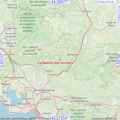
La Bastide-des-Jourdans GPS coordinates[2]
43° 47' 7.116" North, 5° 38' 4.056" East
| Map corner | latitude | longitude |
|---|---|---|
| Upper-left | 44.29077°, | 4.93133° |
| Center: | 43.78531°, | 5.63446° |
| Lower-right: | 43.27554°, | 6.33758° |
| Map W x H: | 112.9×112.9 km | = 70.2×70.2mi |
| max Lat: | 51.07786° ⇑89.3% North |
| La Bastide-des-Jourdans: | 43.78531° |
| min Lat: | ⇓10.7% South 41.3874° |
| min Long | La Bastide-des- | max Long |
| -5.08615° | 5.63446° | 9.52242° |
| W 84%⇐ | ⇒16% E |
Elevation
Elevation of La Bastide-des-Jourdans is 450 m = 1476 ft, and this is 256.3 m = 841 ft above average elevation for this country.
| Max E: |
2333 m = 7654 ft | 9% |
| La Bastide-des-Jourdans | 450 m 1476 ft | |
| Avg. | 193.7 m = 635 ft | |
Min E: |
-1 m = -3 ft | 91% |
See also: France elevation on elevation.city.
Geographical zone
La Bastide-des-Jourdans is located in North temperate zone (between Tropic of Cancer and the Arctic Circle). Distance of this Northern Tropic circle is 2262.6 km =1405.9 mi to South.| Distance of | km | miles | from La Bastide-des-Jourdans |
|---|---|---|---|
| North Pole | 5138.6 | 3193 | to North |
| Arctic Circle | 2532.7 | 1573.7 | to North |
| Tropic Cancer | 2262.6 | 1405.9 | to South |
| Equator | 4868.5 | 3025.1 | to South |


Nearby cities:
15 places around La Bastide-des-Jourdans: (largest is in red/bold)
• Beaumont-de-Pertuis
6.9 km =4.3 mi,  140°
140°
• Corbières-en-Provence
9.8 km =6.1 mi,  106°
106°
• Céreste
8.7 km =5.4 mi,  334°
334°
• Grambois
4.5 km =2.8 mi,  235°
235°
• La Bastidonne
10.8 km =6.7 mi,  209°
209°
• Manosque
13.2 km =8.2 mi,  68°
68°
• Mirabeau
9.2 km =5.7 mi,  169°
169°
• Pertuis
14.6 km =9.1 mi,  226°
226°
• Pierrevert
9.7 km =6 mi, 72°
• Reillanne
10.6 km =6.6 mi,  10°
10°
• Saint-Martin-de-Castillon
12.9 km =8 mi,  309°
309°
• Saint-Martin-de-la-Brasque
8 km =5 mi,  257°
257°
• Saint-Paul-lès-Durance
12.6 km =7.8 mi,  152°
152°
• Sainte-Tulle
10.5 km =6.5 mi,  89°
89°
• Viens
13.4 km =8.3 mi,  335°
335°
Sources, notices
• [Note1] Compared only with cities in France existing in our database
• [Src1] Map data: © OpenStreetMap contributors (CC-BY-SA)
• [Src2] Other city data from geonames.org with taken over terms of usage.
• [Src3] Geographical zone / Annual Mean Temperature by Robert A. Rohde @ Wikipedia
