Saint-Maime geodata
Saint-Maime (Provence-Alpes-Côte d'Azur) is a populated place; located in France in Europe/Paris (GMT+2) time zone. With population of 709 people, there are 11666 cities with bigger population in this country. Compared to other cities in France, 88% of cities are located further ↑North; 85.1% of cities are located further ←West and 89.1% of cities have lower elevation than Saint-Maime. Note1
Administrative division(s):
- Level 1: Provence-Alpes-Côte d'Azur
- Level 2: Alpes-de-Haute-Provence
- Level 3: Arrondissement de Forcalquier
- Level 4: Saint-Maime


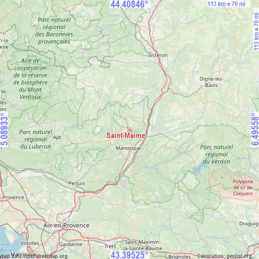
Saint-Maime GPS coordinates[2]
43° 54' 14.436" North, 5° 47' 32.82" East
| Map corner | latitude | longitude |
|---|---|---|
| Upper-left | 44.40846°, | 5.08933° |
| Center: | 43.90401°, | 5.79245° |
| Lower-right: | 43.39525°, | 6.49558° |
| Map W x H: | 112.7×112.7 km | = 70×70mi |
| max Lat: | 51.07786° ⇑88% North |
| Saint-Maime: | 43.90401° |
| min Lat: | ⇓12% South 41.3874° |
| min Long | Saint-Maime | max Long |
| -5.08615° | 5.79245° | 9.52242° |
| W 85.1%⇐ | ⇒14.9% E |
Elevation
Elevation of Saint-Maime is 408 m = 1339 ft, and this is 214.3 m = 703 ft above average elevation for this country.
| Max E: |
2333 m = 7654 ft | 10.9% |
| Saint-Maime | 408 m 1339 ft | |
| Avg. | 193.7 m = 635 ft | |
Min E: |
-1 m = -3 ft | 89.1% |
See also: France elevation on elevation.city.
Geographical zone
Saint-Maime is located in North temperate zone (between Tropic of Cancer and the Arctic Circle). Distance of this Northern Tropic circle is 2275.7 km =1414.1 mi to South.| Distance of | km | miles | from Saint-Maime |
|---|---|---|---|
| North Pole | 5125.4 | 3184.8 | to North |
| Arctic Circle | 2519.5 | 1565.5 | to North |
| Tropic Cancer | 2275.7 | 1414.1 | to South |
| Equator | 4881.7 | 3033.3 | to South |


Nearby cities:
15 places around Saint-Maime: (largest is in red/bold)
• Corbières-en-Provence
16.2 km =10.1 mi,  191°
191°
• Dauphin
1.1 km =0.7 mi,  229°
229°
• Forcalquier
6.2 km =3.9 mi,  350°
350°
• La Brillanne
8.3 km =5.2 mi,  72°
72°
• Mane
4.3 km =2.7 mi,  331°
331°
• Manosque
8.4 km =5.2 mi,  183°
183°
• Oraison
10.2 km =6.3 mi,  81°
81°
• Pierrerue
6.6 km =4.1 mi,  29°
29°
• Pierrevert
10.9 km =6.8 mi,  198°
198°
• Reillanne
11 km =6.8 mi,  255°
255°
• Saint-Michel-l’Observatoire
6.2 km =3.9 mi,  275°
275°
• Saint-Étienne-les-Orgues
15.7 km =9.8 mi,  356°
356°
• Sainte-Tulle
13.3 km =8.3 mi, 189°
• Villeneuve
5.7 km =3.5 mi,  100°
100°
• Volx
4.9 km =3 mi,  126°
126°
Sources, notices
• [Note1] Compared only with cities in France existing in our database
• [Src1] Map data: © OpenStreetMap contributors (CC-BY-SA)
• [Src2] Other city data from geonames.org with taken over terms of usage.
• [Src3] Geographical zone / Annual Mean Temperature by Robert A. Rohde @ Wikipedia
