Pfulgriesheim geodata
Pfulgriesheim (Grand Est) is a populated place; located in France in Europe/Paris (GMT+2) time zone. With population of 1,237 people, there are 7344 cities with bigger population in this country. Compared to other cities in France, 71.9% of cities are located further ↓South; 98.9% of cities are located further ←West and 56.1% of cities have lower elevation than Pfulgriesheim. Note1
Administrative division(s):
- Level 1: Grand Est
- Level 2: Bas-Rhin
- Level 3: Arrondissement de Saverne
- Level 4: Pfulgriesheim


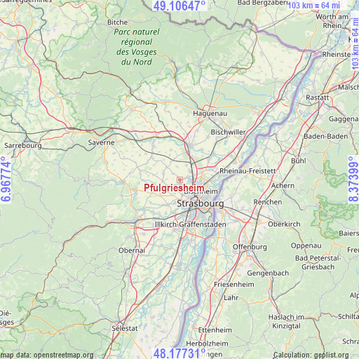
Pfulgriesheim GPS coordinates[2]
48° 38' 38.508" North, 7° 40' 15.096" East
| Map corner | latitude | longitude |
|---|---|---|
| Upper-left | 49.10647°, | 6.96774° |
| Center: | 48.64403°, | 7.67086° |
| Lower-right: | 48.17731°, | 8.37399° |
| Map W x H: | 103.3×103.3 km | = 64.2×64.2mi |
| max Lat: | 51.07786° ⇑28.1% North |
| Pfulgriesheim: | 48.64403° |
| min Lat: | ⇓71.9% South 41.3874° |
| min Long | Pfulgriesheim | max Long |
| -5.08615° | 7.67086° | 9.52242° |
| W 98.9%⇐ | ⇒1.1% E |
Elevation
Elevation of Pfulgriesheim is 154 m = 505 ft, and this is 39.7 m = 130 ft below average elevation for this country.
| Max E: |
2333 m = 7654 ft | 43.9% |
| Avg. | 193.7 m = 635 ft | |
| Pfulgriesheim | 154 m = 505 ft | |
Min E: |
-1 m = -3 ft | 56.1% |
See also: France elevation on elevation.city.
Geographical zone
Pfulgriesheim is located in North temperate zone (between Tropic of Cancer and the Arctic Circle). Distance of this North polar circle is 1992.5 km =1238.1 mi to North.| Distance of | km | miles | from Pfulgriesheim |
|---|---|---|---|
| North Pole | 4598.4 | 2857.3 | to North |
| Arctic Circle | 1992.5 | 1238.1 | to North |
| Tropic Cancer | 2802.8 | 1741.6 | to South |
| Equator | 5408.7 | 3360.8 | to South |


Nearby cities:
15 places around Pfulgriesheim: (largest is in red/bold)
• Berstett
4 km =2.5 mi,  345°
345°
• Dingsheim
1.5 km =0.9 mi,  184°
184°
• Eckwersheim
4.6 km =2.9 mi,  24°
24°
• Griesheim-sur-Souffel
0.9 km =0.6 mi,  187°
187°
• Lampertheim
2.2 km =1.4 mi,  67°
67°
• Mittelhausbergen
3.6 km =2.2 mi,  156°
156°
• Mundolsheim
3.2 km =2 mi,  93°
93°
• Niederhausbergen
3.2 km =2 mi,  134°
134°
• Oberhausbergen
4.4 km =2.7 mi, 162°
• Offenheim
4.2 km =2.6 mi,  251°
251°
• Pfettisheim
2.6 km =1.6 mi,  313°
313°
• Souffelweyersheim
5.3 km =3.3 mi,  100°
100°
• Truchtersheim
5.1 km =3.2 mi,  294°
294°
• Vendenheim
4 km =2.5 mi,  45°
45°
• Wiwersheim
4.8 km =3 mi,  264°
264°
Sources, notices
• [Note1] Compared only with cities in France existing in our database
• [Src1] Map data: © OpenStreetMap contributors (CC-BY-SA)
• [Src2] Other city data from geonames.org with taken over terms of usage.
• [Src3] Geographical zone / Annual Mean Temperature by Robert A. Rohde @ Wikipedia
