Lampertheim geodata
Lampertheim (Grand Est) is a populated place; located in France in Europe/Paris (GMT+2) time zone. With population of 3,126 people, there are 3122 cities with bigger population in this country. Compared to other cities in France, 72.1% of cities are located further ↓South; 99% of cities are located further ←West and 54.7% of cities have lower elevation than Lampertheim. Note1
Administrative division(s):
- Level 1: Grand Est
- Level 2: Bas-Rhin
- Level 3: Arrondissement de Strasbourg
- Level 4: Lampertheim


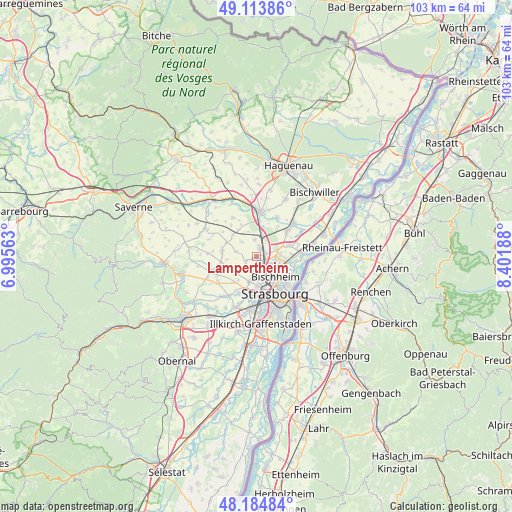
Lampertheim GPS coordinates[2]
48° 39' 5.364" North, 7° 41' 55.536" East
| Map corner | latitude | longitude |
|---|---|---|
| Upper-left | 49.11386°, | 6.99563° |
| Center: | 48.65149°, | 7.69876° |
| Lower-right: | 48.18484°, | 8.40188° |
| Map W x H: | 103.3×103.3 km | = 64.2×64.2mi |
| max Lat: | 51.07786° ⇑27.9% North |
| Lampertheim: | 48.65149° |
| min Lat: | ⇓72.1% South 41.3874° |
| min Long | Lampertheim | max Long |
| -5.08615° | 7.69876° | 9.52242° |
| W 99%⇐ | ⇒1% E |
Elevation
Elevation of Lampertheim is 149 m = 489 ft, and this is 44.7 m = 147 ft below average elevation for this country.
| Max E: |
2333 m = 7654 ft | 45.3% |
| Avg. | 193.7 m = 635 ft | |
| Lampertheim | 149 m = 489 ft | |
Min E: |
-1 m = -3 ft | 54.7% |
See also: France elevation on elevation.city.
Geographical zone
Lampertheim is located in North temperate zone (between Tropic of Cancer and the Arctic Circle). Distance of this North polar circle is 1991.6 km =1237.5 mi to North.| Distance of | km | miles | from Lampertheim |
|---|---|---|---|
| North Pole | 4597.5 | 2856.8 | to North |
| Arctic Circle | 1991.6 | 1237.5 | to North |
| Tropic Cancer | 2803.6 | 1742.1 | to South |
| Equator | 5409.5 | 3361.3 | to South |


Nearby cities:
15 places around Lampertheim: (largest is in red/bold)
• Berstett
4.3 km =2.7 mi,  315°
315°
• Dingsheim
3.2 km =2 mi,  222°
222°
• Eckwersheim
3.4 km =2.1 mi,  357°
357°
• Griesheim-sur-Souffel
2.8 km =1.7 mi,  231°
231°
• Hœnheim
5.3 km =3.3 mi,  127°
127°
• Mittelhausbergen
4.2 km =2.6 mi,  188°
188°
• Mundolsheim
1.5 km =0.9 mi, 133°
• Niederhausbergen
3.1 km =1.9 mi,  175°
175°
• Oberhausbergen
5.1 km =3.2 mi, 188°
• Olwisheim
5.4 km =3.4 mi,  340°
340°
• Pfettisheim
4 km =2.5 mi,  283°
283°
• Pfulgriesheim
2.2 km =1.4 mi,  247°
247°
• Reichstett
4.1 km =2.5 mi,  94°
94°
• Souffelweyersheim
3.6 km =2.2 mi,  119°
119°
• Vendenheim
2.2 km =1.4 mi,  22°
22°
Sources, notices
• [Note1] Compared only with cities in France existing in our database
• [Src1] Map data: © OpenStreetMap contributors (CC-BY-SA)
• [Src2] Other city data from geonames.org with taken over terms of usage.
• [Src3] Geographical zone / Annual Mean Temperature by Robert A. Rohde @ Wikipedia
