Peumerit geodata
Peumerit (Brittany) is a populated place; located in France in Europe/Paris (GMT+2) time zone. With population of 706 people, there are 11718 cities with bigger population in this country. Compared to other cities in France, 58.2% of cities are located further ↓South; 99.5% of cities are located further →East and 69.2% of cities have higher elevation than Peumerit. Note1
Administrative division(s):
- Level 1: Brittany
- Level 2: Département du Finistère
- Level 3: Arrondissement de Quimper
- Level 4: Peumerit


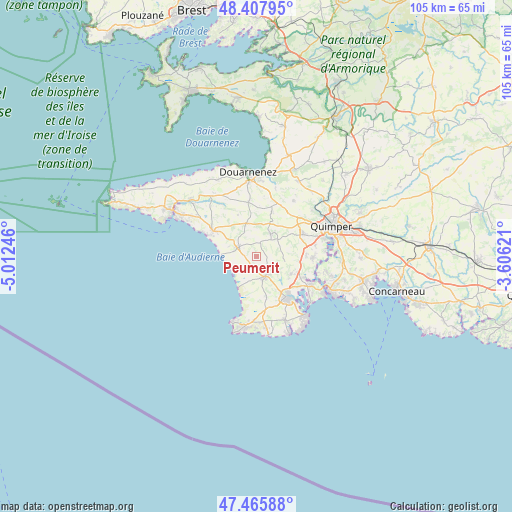
Peumerit GPS coordinates[2]
47° 56' 20.616" North, 4° 18' 33.624" West
| Map corner | latitude | longitude |
|---|---|---|
| Upper-left | 48.40795°, | -5.01246° |
| Center: | 47.93906°, | -4.30934° |
| Lower-right: | 47.46588°, | -3.60621° |
| Map W x H: | 104.7×104.7 km | = 65.1×65.1mi |
| max Lat: | 51.07786° ⇑41.8% North |
| Peumerit: | 47.93906° |
| min Lat: | ⇓58.2% South 41.3874° |
| min Long | Peumerit | max Long |
| -5.08615° | -4.30934° | 9.52242° |
| W 0.5%⇐ | ⇒99.5% E |
Elevation
Elevation of Peumerit is 80 m = 262 ft, and this is 113.7 m = 373 ft below average elevation for this country.
| Max E: |
2333 m = 7654 ft | 69.2% |
| Avg. | 193.7 m = 635 ft | |
| Peumerit | 80 m = 262 ft | |
Min E: |
-1 m = -3 ft | 30.8% |
See also: France elevation on elevation.city.
Geographical zone
Peumerit is located in North temperate zone (between Tropic of Cancer and the Arctic Circle). Distance of this North polar circle is 2070.9 km =1286.8 mi to North.| Distance of | km | miles | from Peumerit |
|---|---|---|---|
| North Pole | 4676.7 | 2906 | to North |
| Arctic Circle | 2070.9 | 1286.8 | to North |
| Tropic Cancer | 2724.4 | 1692.9 | to South |
| Equator | 5330.3 | 3312.1 | to South |


Nearby cities:
15 places around Peumerit: (largest is in red/bold)
• Gourlizon
9.4 km =5.8 mi,  19°
19°
• Landudec
7.1 km =4.4 mi,  343°
343°
• Plogastel-Saint-Germain
5.9 km =3.7 mi,  32°
32°
• Plomelin
11.9 km =7.4 mi,  93°
93°
• Plomeur
11.9 km =7.4 mi,  170°
170°
• Plonéis
11 km =6.8 mi,  38°
38°
• Plonéour-Lanvern
4.8 km =3 mi,  155°
155°
• Plovan
4.9 km =3 mi,  239°
239°
• Plozévet
9.4 km =5.8 mi,  301°
301°
• Pluguffan
10.6 km =6.6 mi,  62°
62°
• Pont-l’Abbé
10.6 km =6.6 mi,  139°
139°
• Pouldergat
12.5 km =7.8 mi,  351°
351°
• Pouldreuzic
4.4 km =2.7 mi,  285°
285°
• Saint-Jean-Trolimon
8.3 km =5.2 mi, 166°
• Tréméoc
8.2 km =5.1 mi,  122°
122°
Sources, notices
• [Note1] Compared only with cities in France existing in our database
• [Src1] Map data: © OpenStreetMap contributors (CC-BY-SA)
• [Src2] Other city data from geonames.org with taken over terms of usage.
• [Src3] Geographical zone / Annual Mean Temperature by Robert A. Rohde @ Wikipedia
