Pluguffan geodata
Pluguffan (Brittany) is a populated place; located in France in Europe/Paris (GMT+2) time zone. With population of 3,370 people, there are 2887 cities with bigger population in this country. Compared to other cities in France, 58.9% of cities are located further ↓South; 99.3% of cities are located further →East and 62% of cities have higher elevation than Pluguffan. Note1
Administrative division(s):
- Level 1: Brittany
- Level 2: Département du Finistère
- Level 3: Arrondissement de Quimper
- Level 4: Pluguffan


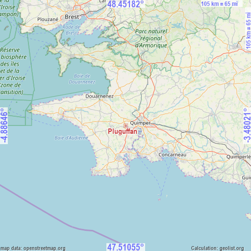
Pluguffan GPS coordinates[2]
47° 58' 59.988" North, 4° 10' 59.988" West
| Map corner | latitude | longitude |
|---|---|---|
| Upper-left | 48.45182°, | -4.88646° |
| Center: | 47.98333°, | -4.18333° |
| Lower-right: | 47.51055°, | -3.48021° |
| Map W x H: | 104.7×104.7 km | = 65.1×65.1mi |
| max Lat: | 51.07786° ⇑41.1% North |
| Pluguffan: | 47.98333° |
| min Lat: | ⇓58.9% South 41.3874° |
| min Long | Pluguffan | max Long |
| -5.08615° | -4.18333° | 9.52242° |
| W 0.7%⇐ | ⇒99.3% E |
Elevation
Elevation of Pluguffan is 97 m = 318 ft, and this is 96.7 m = 317 ft below average elevation for this country.
| Max E: |
2333 m = 7654 ft | 62% |
| Avg. | 193.7 m = 635 ft | |
| Pluguffan | 97 m = 318 ft | |
Min E: |
-1 m = -3 ft | 38% |
See also: France elevation on elevation.city.
Geographical zone
Pluguffan is located in North temperate zone (between Tropic of Cancer and the Arctic Circle). Distance of this North polar circle is 2065.9 km =1283.7 mi to North.| Distance of | km | miles | from Pluguffan |
|---|---|---|---|
| North Pole | 4671.8 | 2902.9 | to North |
| Arctic Circle | 2065.9 | 1283.7 | to North |
| Tropic Cancer | 2729.3 | 1695.9 | to South |
| Equator | 5335.2 | 3315.1 | to South |


Nearby cities:
15 places around Pluguffan: (largest is in red/bold)
• Combrit
10.8 km =6.7 mi,  170°
170°
• Ergué-Gabéric
12.1 km =7.5 mi,  83°
83°
• Gouesnach
9.6 km =6 mi,  147°
147°
• Gourlizon
7.3 km =4.5 mi,  302°
302°
• Guengat
6.7 km =4.2 mi,  346°
346°
• Landudec
11.5 km =7.1 mi,  279°
279°
• Le Juch
10.6 km =6.6 mi,  329°
329°
• Peumerit
10.6 km =6.6 mi,  242°
242°
• Plogastel-Saint-Germain
6.2 km =3.9 mi,  270°
270°
• Plogonnec
11.1 km =6.9 mi,  0°
0°
• Plomelin
6.1 km =3.8 mi,  155°
155°
• Plonéis
4.5 km =2.8 mi, 326°
• Plonéour-Lanvern
11.9 km =7.4 mi,  218°
218°
• Quimper
6.5 km =4 mi,  73°
73°
• Tréméoc
9.6 km =6 mi,  195°
195°
Sources, notices
• [Note1] Compared only with cities in France existing in our database
• [Src1] Map data: © OpenStreetMap contributors (CC-BY-SA)
• [Src2] Other city data from geonames.org with taken over terms of usage.
• [Src3] Geographical zone / Annual Mean Temperature by Robert A. Rohde @ Wikipedia
