Pertuis geodata
Pertuis (Provence-Alpes-Côte d'Azur) is a populated place; located in France in Europe/Paris (GMT+2) time zone. With population of 19,926 people, there are 458 cities with bigger population in this country. Compared to other cities in France, 90.5% of cities are located further ↑North; 82.9% of cities are located further ←West and 70.1% of cities have lower elevation than Pertuis. Note1
Administrative division(s):
- Level 1: Provence-Alpes-Côte d'Azur
- Level 2: Département du Vaucluse
- Level 3: Apt
- Level 4: Pertuis


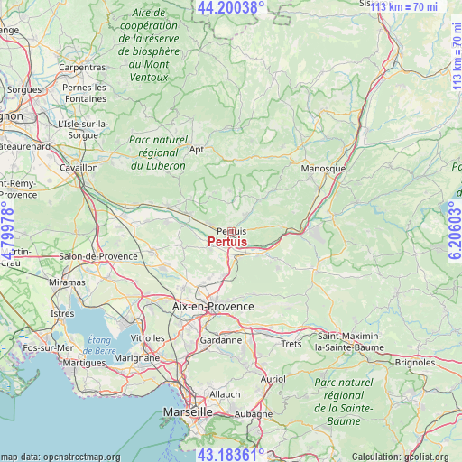
Pertuis GPS coordinates[2]
43° 41' 38.94" North, 5° 30' 10.476" East
| Map corner | latitude | longitude |
|---|---|---|
| Upper-left | 44.20038°, | 4.79978° |
| Center: | 43.69415°, | 5.50291° |
| Lower-right: | 43.18361°, | 6.20603° |
| Map W x H: | 113.1×113.1 km | = 70.3×70.3mi |
| max Lat: | 51.07786° ⇑90.5% North |
| Pertuis: | 43.69415° |
| min Lat: | ⇓9.5% South 41.3874° |
| min Long | Pertuis | max Long |
| -5.08615° | 5.50291° | 9.52242° |
| W 82.9%⇐ | ⇒17.1% E |
Elevation
Elevation of Pertuis is 220 m = 722 ft, and this is 26.3 m = 86 ft above average elevation for this country.
| Max E: |
2333 m = 7654 ft | 29.9% |
| Pertuis | 220 m 722 ft | |
| Avg. | 193.7 m = 635 ft | |
Min E: |
-1 m = -3 ft | 70.1% |
See also: France elevation on elevation.city.
Geographical zone
Pertuis is located in North temperate zone (between Tropic of Cancer and the Arctic Circle). Distance of this Northern Tropic circle is 2252.4 km =1399.6 mi to South.| Distance of | km | miles | from Pertuis |
|---|---|---|---|
| North Pole | 5148.7 | 3199.3 | to North |
| Arctic Circle | 2542.8 | 1580 | to North |
| Tropic Cancer | 2252.4 | 1399.6 | to South |
| Equator | 4858.3 | 3018.8 | to South |


Nearby cities:
15 places around Pertuis: (largest is in red/bold)
• Ansouis
5.8 km =3.6 mi,  326°
326°
• Cadenet
11.4 km =7.1 mi,  293°
293°
• Cucuron
10.2 km =6.3 mi, 329°
• Grambois
10.2 km =6.3 mi,  42°
42°
• Jouques
12.5 km =7.8 mi,  120°
120°
• La Bastidonne
5.2 km =3.2 mi,  81°
81°
• Le Puy-Sainte-Réparade
6.4 km =4 mi,  238°
238°
• Lourmarin
13.7 km =8.5 mi,  304°
304°
• Meyrargues
6.7 km =4.2 mi,  163°
163°
• Mirabeau
12.4 km =7.7 mi, 84°
• Peyrolles-en-Provence
8.5 km =5.3 mi,  129°
129°
• Rognes
13 km =8.1 mi,  254°
254°
• Saint-Martin-de-la-Brasque
8.8 km =5.5 mi,  17°
17°
• Venelles
10.8 km =6.7 mi,  189°
189°
• Villelaure
5.8 km =3.6 mi, 288°
Sources, notices
• [Note1] Compared only with cities in France existing in our database
• [Src1] Map data: © OpenStreetMap contributors (CC-BY-SA)
• [Src2] Other city data from geonames.org with taken over terms of usage.
• [Src3] Geographical zone / Annual Mean Temperature by Robert A. Rohde @ Wikipedia
