Mirabeau geodata
Mirabeau (Provence-Alpes-Côte d'Azur) is a populated place; located in France in Europe/Paris (GMT+2) time zone. With population of 974 people, there are 9031 cities with bigger population in this country. Compared to other cities in France, 90.3% of cities are located further ↑North; 84.1% of cities are located further ←West and 82.7% of cities have lower elevation than Mirabeau. Note1
Administrative division(s):
- Level 1: Provence-Alpes-Côte d'Azur
- Level 2: Département du Vaucluse
- Level 3: Apt
- Level 4: Mirabeau


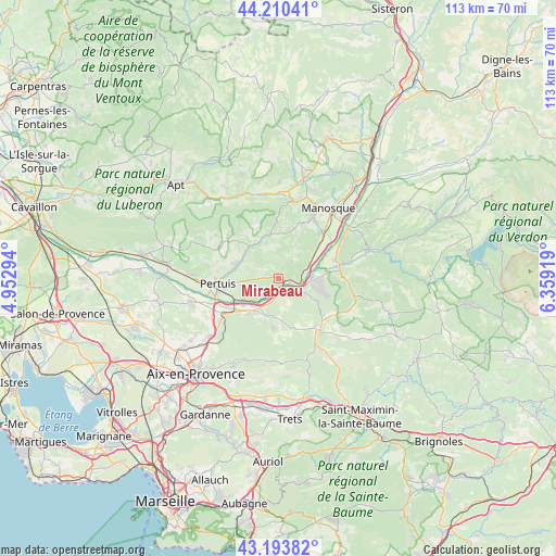
Mirabeau GPS coordinates[2]
43° 42' 15.372" North, 5° 39' 21.816" East
| Map corner | latitude | longitude |
|---|---|---|
| Upper-left | 44.21041°, | 4.95294° |
| Center: | 43.70427°, | 5.65606° |
| Lower-right: | 43.19382°, | 6.35919° |
| Map W x H: | 113×113 km | = 70.2×70.2mi |
| max Lat: | 51.07786° ⇑90.3% North |
| Mirabeau: | 43.70427° |
| min Lat: | ⇓9.7% South 41.3874° |
| min Long | Mirabeau | max Long |
| -5.08615° | 5.65606° | 9.52242° |
| W 84.1%⇐ | ⇒15.9% E |
Elevation
Elevation of Mirabeau is 318 m = 1043 ft, and this is 124.3 m = 408 ft above average elevation for this country.
| Max E: |
2333 m = 7654 ft | 17.3% |
| Mirabeau | 318 m 1043 ft | |
| Avg. | 193.7 m = 635 ft | |
Min E: |
-1 m = -3 ft | 82.7% |
See also: France elevation on elevation.city.
Geographical zone
Mirabeau is located in North temperate zone (between Tropic of Cancer and the Arctic Circle). Distance of this Northern Tropic circle is 2253.5 km =1400.3 mi to South.| Distance of | km | miles | from Mirabeau |
|---|---|---|---|
| North Pole | 5147.6 | 3198.6 | to North |
| Arctic Circle | 2541.7 | 1579.3 | to North |
| Tropic Cancer | 2253.5 | 1400.3 | to South |
| Equator | 4859.5 | 3019.6 | to South |


Nearby cities:
15 places around Mirabeau: (largest is in red/bold)
• Beaumont-de-Pertuis
4.6 km =2.9 mi,  36°
36°
• Corbières-en-Provence
9.9 km =6.2 mi,  50°
50°
• Grambois
8.4 km =5.2 mi,  319°
319°
• Jouques
7.6 km =4.7 mi,  191°
191°
• La Bastide-des-Jourdans
9.2 km =5.7 mi,  349°
349°
• La Bastidonne
7.1 km =4.4 mi,  267°
267°
• Meyrargues
12.8 km =8 mi,  234°
234°
• Pertuis
12.4 km =7.7 mi,  264°
264°
• Peyrolles-en-Provence
8.7 km =5.4 mi,  221°
221°
• Pierrevert
14.1 km =8.8 mi,  32°
32°
• Rians
13.5 km =8.4 mi,  143°
143°
• Saint-Martin-de-la-Brasque
12 km =7.5 mi,  307°
307°
• Saint-Paul-lès-Durance
4.7 km =2.9 mi,  117°
117°
• Sainte-Tulle
12.6 km =7.8 mi, 43°
• Vinon-sur-Verdon
12.7 km =7.9 mi,  79°
79°
Sources, notices
• [Note1] Compared only with cities in France existing in our database
• [Src1] Map data: © OpenStreetMap contributors (CC-BY-SA)
• [Src2] Other city data from geonames.org with taken over terms of usage.
• [Src3] Geographical zone / Annual Mean Temperature by Robert A. Rohde @ Wikipedia
