Persan geodata
Persan (Île-de-France) is a populated place; located in France in Europe/Paris (GMT+2) time zone. With population of 9,314 people, there are 1031 cities with bigger population in this country. Compared to other cities in France, 83.3% of cities are located further ↓South; 53.1% of cities are located further →East and 91.2% of cities have higher elevation than Persan. Note1
Administrative division(s):
- Level 1: Île-de-France
- Level 2: Département du Val-d’Oise
- Level 3: Arrondissement de Pontoise
- Level 4: Persan


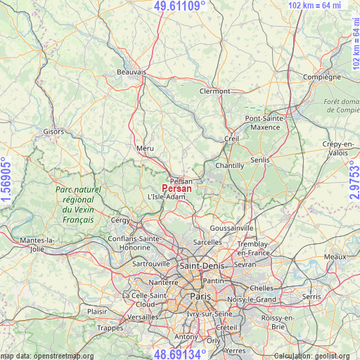
Persan GPS coordinates[2]
49° 9' 12.06" North, 2° 16' 19.848" East
| Map corner | latitude | longitude |
|---|---|---|
| Upper-left | 49.61109°, | 1.56905° |
| Center: | 49.15335°, | 2.27218° |
| Lower-right: | 48.69134°, | 2.9753° |
| Map W x H: | 102.3×102.3 km | = 63.6×63.6mi |
| max Lat: | 51.07786° ⇑16.7% North |
| Persan: | 49.15335° |
| min Lat: | ⇓83.3% South 41.3874° |
| min Long | Persan | max Long |
| -5.08615° | 2.27218° | 9.52242° |
| W 46.9%⇐ | ⇒53.1% E |
Elevation
Elevation of Persan is 27 m = 89 ft, and this is 166.7 m = 547 ft below average elevation for this country.
| Max E: |
2333 m = 7654 ft | 91.2% |
| Avg. | 193.7 m = 635 ft | |
| Persan | 27 m = 89 ft | |
Min E: |
-1 m = -3 ft | 8.8% |
See also: France elevation on elevation.city.
Geographical zone
Persan is located in North temperate zone (between Tropic of Cancer and the Arctic Circle). Distance of this North polar circle is 1935.8 km =1202.8 mi to North.| Distance of | km | miles | from Persan |
|---|---|---|---|
| North Pole | 4541.7 | 2822.1 | to North |
| Arctic Circle | 1935.8 | 1202.8 | to North |
| Tropic Cancer | 2859.4 | 1776.7 | to South |
| Equator | 5465.3 | 3396 | to South |


Nearby cities:
15 places around Persan: (largest is in red/bold)
• Beaumont-sur-Oise
1.6 km =1 mi,  138°
138°
• Belle-Église
5.8 km =3.6 mi,  318°
318°
• Bernes-sur-Oise
2.2 km =1.4 mi,  66°
66°
• Boran-sur-Oise
6.4 km =4 mi,  76°
76°
• Bruyères-sur-Oise
3.9 km =2.4 mi, 83°
• Chambly
2.2 km =1.4 mi,  312°
312°
• Champagne-sur-Oise
2.6 km =1.6 mi,  236°
236°
• Fresnoy-en-Thelle
5.2 km =3.2 mi,  357°
357°
• Le Mesnil-en-Thelle
2.9 km =1.8 mi,  19°
19°
• L’Isle-Adam
6 km =3.7 mi,  212°
212°
• Mours
2.5 km =1.6 mi,  187°
187°
• Nointel
3.1 km =1.9 mi,  154°
154°
• Noisy-sur-Oise
4.6 km =2.9 mi,  113°
113°
• Parmain
6.2 km =3.9 mi,  222°
222°
• Ronquerolles
3.8 km =2.4 mi,  292°
292°
Sources, notices
• [Note1] Compared only with cities in France existing in our database
• [Src1] Map data: © OpenStreetMap contributors (CC-BY-SA)
• [Src2] Other city data from geonames.org with taken over terms of usage.
• [Src3] Geographical zone / Annual Mean Temperature by Robert A. Rohde @ Wikipedia
