Bruyères-sur-Oise geodata
Bruyères-sur-Oise (Île-de-France) is a populated place; located in France in Europe/Paris (GMT+2) time zone. With population of 3,619 people, there are 2698 cities with bigger population in this country. Compared to other cities in France, 83.4% of cities are located further ↓South; 52.3% of cities are located further →East and 89.9% of cities have higher elevation than Bruyères-sur-Oise. Note1
Administrative division(s):
- Level 1: Île-de-France
- Level 2: Département du Val-d’Oise
- Level 3: Arrondissement de Pontoise
- Level 4: Bruyères-sur-Oise


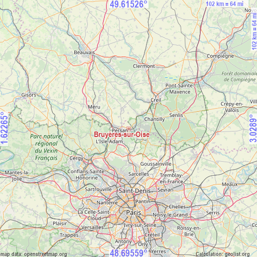
Bruyères-sur-Oise GPS coordinates[2]
49° 9' 27.216" North, 2° 19' 32.772" East
| Map corner | latitude | longitude |
|---|---|---|
| Upper-left | 49.61526°, | 1.62265° |
| Center: | 49.15756°, | 2.32577° |
| Lower-right: | 48.69559°, | 3.0289° |
| Map W x H: | 102.3×102.3 km | = 63.6×63.6mi |
| max Lat: | 51.07786° ⇑16.6% North |
| Bruyères-sur-Oise: | 49.15756° |
| min Lat: | ⇓83.4% South 41.3874° |
| min Long | Bruyères-sur-O | max Long |
| -5.08615° | 2.32577° | 9.52242° |
| W 47.7%⇐ | ⇒52.3% E |
Elevation
Elevation of Bruyères-sur-Oise is 30 m = 98 ft, and this is 163.7 m = 537 ft below average elevation for this country.
| Max E: |
2333 m = 7654 ft | 89.9% |
| Avg. | 193.7 m = 635 ft | |
| Bruyères-sur-Oise | 30 m = 98 ft | |
Min E: |
-1 m = -3 ft | 10.1% |
See also: France elevation on elevation.city.
Geographical zone
Bruyères-sur-Oise is located in North temperate zone (between Tropic of Cancer and the Arctic Circle). Distance of this North polar circle is 1935.4 km =1202.6 mi to North.| Distance of | km | miles | from Bruyères-sur-Oise |
|---|---|---|---|
| North Pole | 4541.3 | 2821.8 | to North |
| Arctic Circle | 1935.4 | 1202.6 | to North |
| Tropic Cancer | 2859.9 | 1777.1 | to South |
| Equator | 5465.8 | 3396.3 | to South |


Nearby cities:
15 places around Bruyères-sur-Oise: (largest is in red/bold)
• Asnières-sur-Oise
3.4 km =2.1 mi,  140°
140°
• Beaumont-sur-Oise
3.3 km =2.1 mi,  238°
238°
• Bernes-sur-Oise
1.9 km =1.2 mi,  282°
282°
• Boran-sur-Oise
2.6 km =1.6 mi,  65°
65°
• Chambly
5.6 km =3.5 mi, 280°
• Champagne-sur-Oise
6.4 km =4 mi,  252°
252°
• Fresnoy-en-Thelle
6.3 km =3.9 mi,  319°
319°
• Le Mesnil-en-Thelle
3.7 km =2.3 mi,  308°
308°
• Mours
5.2 km =3.2 mi,  234°
234°
• Nointel
4.1 km =2.5 mi,  218°
218°
• Noisy-sur-Oise
2.3 km =1.4 mi,  171°
171°
• Persan
3.9 km =2.4 mi,  263°
263°
• Saint-Martin-du-Tertre
5.8 km =3.6 mi, 165°
• Seugy
6.3 km =3.9 mi,  128°
128°
• Viarmes
4.4 km =2.7 mi, 132°
Sources, notices
• [Note1] Compared only with cities in France existing in our database
• [Src1] Map data: © OpenStreetMap contributors (CC-BY-SA)
• [Src2] Other city data from geonames.org with taken over terms of usage.
• [Src3] Geographical zone / Annual Mean Temperature by Robert A. Rohde @ Wikipedia
