Chambly geodata
Chambly (Hauts-de-France) is a populated place; located in France in Europe/Paris (GMT+2) time zone. With population of 9,506 people, there are 1004 cities with bigger population in this country. Compared to other cities in France, 83.6% of cities are located further ↓South; 53.5% of cities are located further →East and 87.1% of cities have higher elevation than Chambly. Note1
Administrative division(s):
- Level 1: Hauts-de-France
- Level 2: Département de l'Oise
- Level 3: Arrondissement de Senlis
- Level 4: Chambly


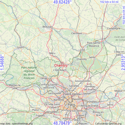
Chambly GPS coordinates[2]
49° 10' 0.012" North, 2° 15' 0" East
| Map corner | latitude | longitude |
|---|---|---|
| Upper-left | 49.62428°, | 1.54688° |
| Center: | 49.16667°, | 2.25° |
| Lower-right: | 48.70479°, | 2.95313° |
| Map W x H: | 102.2×102.2 km | = 63.5×63.5mi |
| max Lat: | 51.07786° ⇑16.4% North |
| Chambly: | 49.16667° |
| min Lat: | ⇓83.6% South 41.3874° |
| min Long | Chambly | max Long |
| -5.08615° | 2.25° | 9.52242° |
| W 46.5%⇐ | ⇒53.5% E |
Elevation
Elevation of Chambly is 37 m = 121 ft, and this is 156.7 m = 514 ft below average elevation for this country.
| Max E: |
2333 m = 7654 ft | 87.1% |
| Avg. | 193.7 m = 635 ft | |
| Chambly | 37 m = 121 ft | |
Min E: |
-1 m = -3 ft | 12.9% |
See also: France elevation on elevation.city.
Geographical zone
Chambly is located in North temperate zone (between Tropic of Cancer and the Arctic Circle). Distance of this North polar circle is 1934.4 km =1202 mi to North.| Distance of | km | miles | from Chambly |
|---|---|---|---|
| North Pole | 4540.2 | 2821.1 | to North |
| Arctic Circle | 1934.4 | 1202 | to North |
| Tropic Cancer | 2860.9 | 1777.7 | to South |
| Equator | 5466.8 | 3396.9 | to South |


Nearby cities:
15 places around Chambly: (largest is in red/bold)
• Beaumont-sur-Oise
3.8 km =2.4 mi,  135°
135°
• Belle-Église
3.6 km =2.2 mi,  321°
321°
• Bernes-sur-Oise
3.7 km =2.3 mi,  99°
99°
• Bornel
4.6 km =2.9 mi, 319°
• Bruyères-sur-Oise
5.6 km =3.5 mi, 100°
• Champagne-sur-Oise
3 km =1.9 mi,  190°
190°
• Fresnoy-en-Thelle
4 km =2.5 mi,  20°
20°
• Le Mesnil-en-Thelle
2.9 km =1.8 mi,  63°
63°
• Mours
4.2 km =2.6 mi,  162°
162°
• Nointel
5.2 km =3.2 mi,  145°
145°
• Noisy-sur-Oise
6.7 km =4.2 mi,  119°
119°
• Parmain
6.5 km =4 mi,  202°
202°
• Persan
2.2 km =1.4 mi,  132°
132°
• Puiseux-le-Hauberger
5.7 km =3.5 mi,  350°
350°
• Ronquerolles
1.9 km =1.2 mi,  270°
270°
Sources, notices
• [Note1] Compared only with cities in France existing in our database
• [Src1] Map data: © OpenStreetMap contributors (CC-BY-SA)
• [Src2] Other city data from geonames.org with taken over terms of usage.
• [Src3] Geographical zone / Annual Mean Temperature by Robert A. Rohde @ Wikipedia
