Belle-Église geodata
Belle-Église (Hauts-de-France) is a populated place; located in France in Europe/Paris (GMT+2) time zone. With population of 583 people, there are 13590 cities with bigger population in this country. Compared to other cities in France, 84.1% of cities are located further ↓South; 54.1% of cities are located further →East and 77.3% of cities have higher elevation than Belle-Église. Note1
Administrative division(s):
- Level 1: Hauts-de-France
- Level 2: Département de l'Oise
- Level 3: Arrondissement de Senlis
- Level 4: Belle-Église


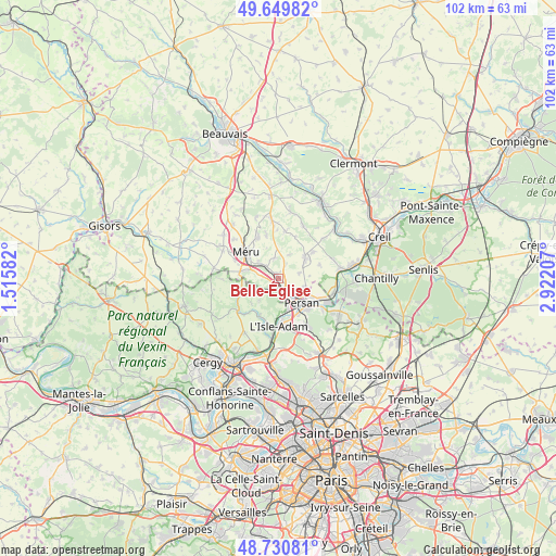
Belle-Église GPS coordinates[2]
49° 11' 32.82" North, 2° 13' 8.184" East
| Map corner | latitude | longitude |
|---|---|---|
| Upper-left | 49.64982°, | 1.51582° |
| Center: | 49.19245°, | 2.21894° |
| Lower-right: | 48.73081°, | 2.92207° |
| Map W x H: | 102.2×102.2 km | = 63.5×63.5mi |
| max Lat: | 51.07786° ⇑15.9% North |
| Belle-Église: | 49.19245° |
| min Lat: | ⇓84.1% South 41.3874° |
| min Long | Belle-Église | max Long |
| -5.08615° | 2.21894° | 9.52242° |
| W 45.9%⇐ | ⇒54.1% E |
Elevation
Elevation of Belle-Église is 61 m = 200 ft, and this is 132.7 m = 435 ft below average elevation for this country.
| Max E: |
2333 m = 7654 ft | 77.3% |
| Avg. | 193.7 m = 635 ft | |
| Belle-Église | 61 m = 200 ft | |
Min E: |
-1 m = -3 ft | 22.7% |
See also: France elevation on elevation.city.
Geographical zone
Belle-Église is located in North temperate zone (between Tropic of Cancer and the Arctic Circle). Distance of this North polar circle is 1931.5 km =1200.2 mi to North.| Distance of | km | miles | from Belle-Église |
|---|---|---|---|
| North Pole | 4537.4 | 2819.4 | to North |
| Arctic Circle | 1931.5 | 1200.2 | to North |
| Tropic Cancer | 2863.8 | 1779.5 | to South |
| Equator | 5469.7 | 3398.7 | to South |


Nearby cities:
15 places around Belle-Église: (largest is in red/bold)
• Amblainville
7.1 km =4.4 mi,  280°
280°
• Beaumont-sur-Oise
7.5 km =4.7 mi,  138°
138°
• Bernes-sur-Oise
6.8 km =4.2 mi,  120°
120°
• Bornel
1 km =0.6 mi,  311°
311°
• Chambly
3.6 km =2.2 mi, 141°
• Champagne-sur-Oise
6 km =3.7 mi,  163°
163°
• Esches
5 km =3.1 mi, 309°
• Fosseuse
3.2 km =2 mi, 314°
• Fresnoy-en-Thelle
3.8 km =2.4 mi,  76°
76°
• Le Mesnil-en-Thelle
5.1 km =3.2 mi,  107°
107°
• Nesles-la-Vallée
7.6 km =4.7 mi,  207°
207°
• Neuilly-en-Thelle
6 km =3.7 mi,  53°
53°
• Persan
5.8 km =3.6 mi, 138°
• Puiseux-le-Hauberger
3 km =1.9 mi,  25°
25°
• Ronquerolles
2.9 km =1.8 mi,  173°
173°
Sources, notices
• [Note1] Compared only with cities in France existing in our database
• [Src1] Map data: © OpenStreetMap contributors (CC-BY-SA)
• [Src2] Other city data from geonames.org with taken over terms of usage.
• [Src3] Geographical zone / Annual Mean Temperature by Robert A. Rohde @ Wikipedia
