Perrusson geodata
Perrusson (Centre) is a populated place; located in France in Europe/Paris (GMT+2) time zone. With population of 1,511 people, there are 6153 cities with bigger population in this country. Compared to other cities in France, 54.2% of cities are located further ↑North; 68.7% of cities are located further →East and 69.2% of cities have higher elevation than Perrusson. Note1
Administrative division(s):
- Level 1: Centre
- Level 2: Département d'Indre-et-Loire
- Level 3: Arrondissement de Loches
- Level 4: Perrusson


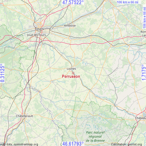
Perrusson GPS coordinates[2]
47° 5' 55.428" North, 1° 0' 51.768" East
| Map corner | latitude | longitude |
|---|---|---|
| Upper-left | 47.57522°, | 0.31125° |
| Center: | 47.09873°, | 1.01438° |
| Lower-right: | 46.61793°, | 1.7175° |
| Map W x H: | 106.4×106.4 km | = 66.1×66.1mi |
| max Lat: | 51.07786° ⇑54.2% North |
| Perrusson: | 47.09873° |
| min Lat: | ⇓45.8% South 41.3874° |
| min Long | Perrusson | max Long |
| -5.08615° | 1.01438° | 9.52242° |
| W 31.3%⇐ | ⇒68.7% E |
Elevation
Elevation of Perrusson is 80 m = 262 ft, and this is 113.7 m = 373 ft below average elevation for this country.
| Max E: |
2333 m = 7654 ft | 69.2% |
| Avg. | 193.7 m = 635 ft | |
| Perrusson | 80 m = 262 ft | |
Min E: |
-1 m = -3 ft | 30.8% |
See also: France elevation on elevation.city.
Geographical zone
Perrusson is located in North temperate zone (between Tropic of Cancer and the Arctic Circle). Distance of this North polar circle is 2164.3 km =1344.8 mi to North.| Distance of | km | miles | from Perrusson |
|---|---|---|---|
| North Pole | 4770.2 | 2964.1 | to North |
| Arctic Circle | 2164.3 | 1344.8 | to North |
| Tropic Cancer | 2631 | 1634.8 | to South |
| Equator | 5236.9 | 3254.1 | to South |


Nearby cities:
15 places around Perrusson: (largest is in red/bold)
• Beaulieu-lès-Loches
3 km =1.9 mi,  2°
2°
• Betz-le-Château
13.9 km =8.6 mi,  211°
211°
• Bridoré
9.4 km =5.8 mi,  146°
146°
• Chambourg-sur-Indre
9.8 km =6.1 mi,  339°
339°
• Dolus-le-Sec
11.7 km =7.3 mi,  309°
309°
• Ferrière-sur-Beaulieu
4.7 km =2.9 mi,  22°
22°
• Fléré-la-Rivière
11.3 km =7 mi,  140°
140°
• Genillé
11.4 km =7.1 mi,  34°
34°
• Ligueil
16.1 km =10 mi,  246°
246°
• Loches
3.6 km =2.2 mi, 336°
• Loché-sur-Indrois
15.6 km =9.7 mi,  92°
92°
• Saint-Flovier
14.5 km =9 mi,  176°
176°
• Saint-Hippolyte
7.8 km =4.8 mi,  124°
124°
• Saint-Jean-Saint-Germain
2.4 km =1.5 mi, 137°
• Verneuil-sur-Indre
5.2 km =3.2 mi,  157°
157°
Sources, notices
• [Note1] Compared only with cities in France existing in our database
• [Src1] Map data: © OpenStreetMap contributors (CC-BY-SA)
• [Src2] Other city data from geonames.org with taken over terms of usage.
• [Src3] Geographical zone / Annual Mean Temperature by Robert A. Rohde @ Wikipedia
