Loches geodata
Loches (Centre) is a seat of a third-order administrative division; located in France in Europe/Paris (GMT+1) time zone. With population of 7,132 people, there are 1364 cities with bigger population in this country. Compared to other cities in France, 53.9% of cities are located further ↑North; 68.8% of cities are located further →East and 74.1% of cities have higher elevation than Loches. Note1
Administrative division(s):
- Level 1: Centre
- Level 2: Département d'Indre-et-Loire
- Level 3: Arrondissement de Loches
- Level 4: Loches


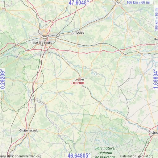
Loches GPS coordinates[2]
47° 7' 42.888" North, 0° 59' 42.792" East
| Map corner | latitude | longitude |
|---|---|---|
| Upper-left | 47.6048°, | 0.29209° |
| Center: | 47.12858°, | 0.99522° |
| Lower-right: | 46.64805°, | 1.69834° |
| Map W x H: | 106.4×106.4 km | = 66.1×66.1mi |
| max Lat: | 51.07786° ⇑53.9% North |
| Loches: | 47.12858° |
| min Lat: | ⇓46.1% South 41.3874° |
| min Long | Loches | max Long |
| -5.08615° | 0.99522° | 9.52242° |
| W 31.2%⇐ | ⇒68.8% E |
Elevation
Elevation of Loches is 69 m = 226 ft, and this is 124.7 m = 409 ft below average elevation for this country.
| Max E: |
2333 m = 7654 ft | 74.1% |
| Avg. | 193.7 m = 635 ft | |
| Loches | 69 m = 226 ft | |
Min E: |
-1 m = -3 ft | 25.9% |
See also: France elevation on elevation.city.
Geographical zone
Loches is located in North temperate zone (between Tropic of Cancer and the Arctic Circle). Distance of this North polar circle is 2161 km =1342.8 mi to North.| Distance of | km | miles | from Loches |
|---|---|---|---|
| North Pole | 4766.9 | 2962 | to North |
| Arctic Circle | 2161 | 1342.8 | to North |
| Tropic Cancer | 2634.3 | 1636.9 | to South |
| Equator | 5240.2 | 3256.1 | to South |


Nearby cities:
15 places around Loches: (largest is in red/bold)
• Beaulieu-lès-Loches
1.6 km =1 mi,  103°
103°
• Bridoré
13 km =8.1 mi,  149°
149°
• Chambourg-sur-Indre
6.2 km =3.9 mi,  341°
341°
• Dolus-le-Sec
8.7 km =5.4 mi,  297°
297°
• Ferrière-sur-Beaulieu
3.4 km =2.1 mi,  72°
72°
• Fléré-la-Rivière
14.8 km =9.2 mi,  144°
144°
• Genillé
10 km =6.2 mi,  52°
52°
• Luzillé
15.7 km =9.8 mi,  18°
18°
• Manthelan
15.3 km =9.5 mi,  273°
273°
• Perrusson
3.6 km =2.2 mi,  156°
156°
• Reignac-sur-Indre
12.4 km =7.7 mi,  331°
331°
• Saint-Hippolyte
11.1 km =6.9 mi,  134°
134°
• Saint-Jean-Saint-Germain
5.9 km =3.7 mi, 149°
• Tauxigny
15.4 km =9.6 mi,  307°
307°
• Verneuil-sur-Indre
8.8 km =5.5 mi, 157°
In other languages:
- In German: Schloss Loches
- In Italian: Loches, Castello di Loches
- In Russian: Лош
- In Chinese: 洛什
Sources, notices
• [Note1] Compared only with cities in France existing in our database
• [Src1] Map data: © OpenStreetMap contributors (CC-BY-SA)
• [Src2] Other city data from geonames.org with taken over terms of usage.
• [Src3] Geographical zone / Annual Mean Temperature by Robert A. Rohde @ Wikipedia
