Ligueil geodata
Ligueil (Centre) is a populated place; located in France in Europe/Paris (GMT+2) time zone. With population of 2,187 people, there are 4391 cities with bigger population in this country. Compared to other cities in France, 54.9% of cities are located further ↑North; 70.4% of cities are located further →East and 69.7% of cities have higher elevation than Ligueil. Note1
Administrative division(s):
- Level 1: Centre
- Level 2: Département d'Indre-et-Loire
- Level 3: Arrondissement de Loches
- Level 4: Ligueil


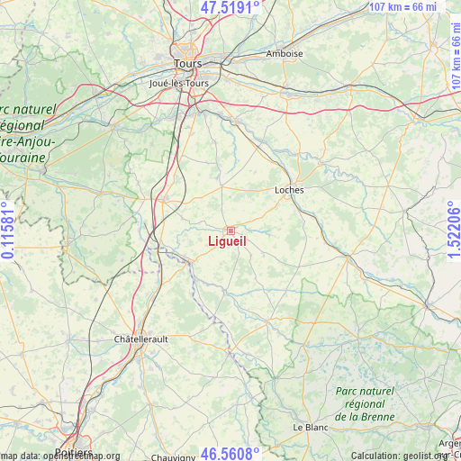
Ligueil GPS coordinates[2]
47° 2' 31.56" North, 0° 49' 8.148" East
| Map corner | latitude | longitude |
|---|---|---|
| Upper-left | 47.5191°, | 0.11581° |
| Center: | 47.0421°, | 0.81893° |
| Lower-right: | 46.5608°, | 1.52206° |
| Map W x H: | 106.6×106.6 km | = 66.2×66.2mi |
| max Lat: | 51.07786° ⇑54.9% North |
| Ligueil: | 47.0421° |
| min Lat: | ⇓45.1% South 41.3874° |
| min Long | Ligueil | max Long |
| -5.08615° | 0.81893° | 9.52242° |
| W 29.6%⇐ | ⇒70.4% E |
Elevation
Elevation of Ligueil is 79 m = 259 ft, and this is 114.7 m = 376 ft below average elevation for this country.
| Max E: |
2333 m = 7654 ft | 69.7% |
| Avg. | 193.7 m = 635 ft | |
| Ligueil | 79 m = 259 ft | |
Min E: |
-1 m = -3 ft | 30.3% |
See also: France elevation on elevation.city.
Geographical zone
Ligueil is located in North temperate zone (between Tropic of Cancer and the Arctic Circle). Distance of this North polar circle is 2170.6 km =1348.7 mi to North.| Distance of | km | miles | from Ligueil |
|---|---|---|---|
| North Pole | 4776.5 | 2968 | to North |
| Arctic Circle | 2170.6 | 1348.7 | to North |
| Tropic Cancer | 2624.7 | 1630.9 | to South |
| Equator | 5230.6 | 3250.1 | to South |


Nearby cities:
15 places around Ligueil: (largest is in red/bold)
• Abilly
13.7 km =8.5 mi,  208°
208°
• Betz-le-Château
9.5 km =5.9 mi,  126°
126°
• Cussay
3 km =1.9 mi,  229°
229°
• Descartes
12.3 km =7.6 mi, 227°
• Dolus-le-Sec
14.8 km =9.2 mi,  22°
22°
• Draché
14.7 km =9.1 mi,  275°
275°
• La Celle-Saint-Avant
16.4 km =10.2 mi,  262°
262°
• La Chapelle-Blanche-Saint-Martin
5.3 km =3.3 mi,  337°
337°
• Le Grand-Pressigny
13.6 km =8.5 mi,  184°
184°
• Loches
16.4 km =10.2 mi,  54°
54°
• Louans
16.7 km =10.4 mi, 341°
• Manthelan
10.7 km =6.6 mi,  349°
349°
• Perrusson
16.1 km =10 mi,  66°
66°
• Sainte-Maure-de-Touraine
16.8 km =10.4 mi,  297°
297°
• Verneuil-sur-Indre
16.8 km =10.4 mi,  84°
84°
Sources, notices
• [Note1] Compared only with cities in France existing in our database
• [Src1] Map data: © OpenStreetMap contributors (CC-BY-SA)
• [Src2] Other city data from geonames.org with taken over terms of usage.
• [Src3] Geographical zone / Annual Mean Temperature by Robert A. Rohde @ Wikipedia
