Pérouges geodata
Pérouges (Auvergne-Rhône-Alpes) is a populated place; located in France in Europe/Paris (GMT+2) time zone. With population of 1,208 people, there are 7482 cities with bigger population in this country. Compared to other cities in France, 67.5% of cities are located further ↑North; 79.5% of cities are located further ←West and 71.8% of cities have lower elevation than Pérouges. Note1
Administrative division(s):
- Level 1: Auvergne-Rhône-Alpes
- Level 2: Département de l'Ain
- Level 3: Arrondissement de Belley
- Level 4: Pérouges


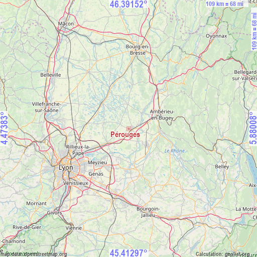
Pérouges GPS coordinates[2]
45° 54' 15.84" North, 5° 10' 37.02" East
| Map corner | latitude | longitude |
|---|---|---|
| Upper-left | 46.39152°, | 4.47383° |
| Center: | 45.9044°, | 5.17695° |
| Lower-right: | 45.41297°, | 5.88008° |
| Map W x H: | 108.8×108.8 km | = 67.6×67.6mi |
| max Lat: | 51.07786° ⇑67.5% North |
| Pérouges: | 45.9044° |
| min Lat: | ⇓32.5% South 41.3874° |
| min Long | Pérouges | max Long |
| -5.08615° | 5.17695° | 9.52242° |
| W 79.5%⇐ | ⇒20.5% E |
Elevation
Elevation of Pérouges is 229 m = 751 ft, and this is 35.3 m = 116 ft above average elevation for this country.
| Max E: |
2333 m = 7654 ft | 28.2% |
| Pérouges | 229 m 751 ft | |
| Avg. | 193.7 m = 635 ft | |
Min E: |
-1 m = -3 ft | 71.8% |
See also: France elevation on elevation.city.
Geographical zone
Pérouges is located in North temperate zone (between Tropic of Cancer and the Arctic Circle). Distance of this North polar circle is 2297.1 km =1427.4 mi to North.| Distance of | km | miles | from Pérouges |
|---|---|---|---|
| North Pole | 4903 | 3046.6 | to North |
| Arctic Circle | 2297.1 | 1427.4 | to North |
| Tropic Cancer | 2498.2 | 1552.3 | to South |
| Equator | 5104.1 | 3171.5 | to South |


Nearby cities:
15 places around Pérouges: (largest is in red/bold)
• Blyes
8.5 km =5.3 mi,  137°
137°
• Bourg-Saint-Christophe
2.8 km =1.7 mi,  227°
227°
• Bressolles
7.5 km =4.7 mi,  236°
236°
• Béligneux
5.6 km =3.5 mi,  223°
223°
• Charnoz-sur-Ain
5.2 km =3.2 mi, 143°
• Chazey-sur-Ain
6.1 km =3.8 mi,  102°
102°
• Châtillon-la-Palud
9.5 km =5.9 mi,  38°
38°
• Faramans
3.9 km =2.4 mi,  269°
269°
• Leyment
9.2 km =5.7 mi,  76°
76°
• Meximieux
1.8 km =1.1 mi, 76°
• Pizay
7 km =4.3 mi,  253°
253°
• Rignieux-le-Franc
4.1 km =2.5 mi,  9°
9°
• Saint-Jean-de-Niost
8.5 km =5.3 mi,  158°
158°
• Saint-Maurice-de-Gourdans
9.2 km =5.7 mi,  171°
171°
• Sainte-Julie
8 km =5 mi, 101°
Sources, notices
• [Note1] Compared only with cities in France existing in our database
• [Src1] Map data: © OpenStreetMap contributors (CC-BY-SA)
• [Src2] Other city data from geonames.org with taken over terms of usage.
• [Src3] Geographical zone / Annual Mean Temperature by Robert A. Rohde @ Wikipedia
