Fontès geodata
Fontès (Occitanie) is a populated place; located in France in Europe/Paris (GMT+2) time zone. With population of 884 people, there are 9787 cities with bigger population in this country. Compared to other cities in France, 92.6% of cities are located further ↑North; 63% of cities are located further ←West and 60% of cities have higher elevation than Fontès. Note1
Administrative division(s):
- Level 1: Occitanie
- Level 2: Département de l'Hérault
- Level 3: Arrondissement de Lodève
- Level 4: Fontès


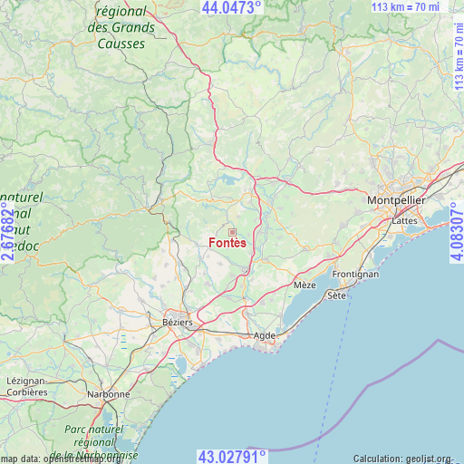
Fontès GPS coordinates[2]
43° 32' 23.136" North, 3° 22' 47.784" East
| Map corner | latitude | longitude |
|---|---|---|
| Upper-left | 44.0473°, | 2.67682° |
| Center: | 43.53976°, | 3.37994° |
| Lower-right: | 43.02791°, | 4.08307° |
| Map W x H: | 113.3×113.3 km | = 70.4×70.4mi |
| max Lat: | 51.07786° ⇑92.6% North |
| Fontès: | 43.53976° |
| min Lat: | ⇓7.4% South 41.3874° |
| min Long | Fontès | max Long |
| -5.08615° | 3.37994° | 9.52242° |
| W 63%⇐ | ⇒37% E |
Elevation
Elevation of Fontès is 102 m = 335 ft, and this is 91.7 m = 301 ft below average elevation for this country.
| Max E: |
2333 m = 7654 ft | 60% |
| Avg. | 193.7 m = 635 ft | |
| Fontès | 102 m = 335 ft | |
Min E: |
-1 m = -3 ft | 40% |
See also: France elevation on elevation.city.
Geographical zone
Fontès is located in North temperate zone (between Tropic of Cancer and the Arctic Circle). Distance of this Northern Tropic circle is 2235.2 km =1388.9 mi to South.| Distance of | km | miles | from Fontès |
|---|---|---|---|
| North Pole | 5165.9 | 3209.9 | to North |
| Arctic Circle | 2560 | 1590.7 | to North |
| Tropic Cancer | 2235.2 | 1388.9 | to South |
| Equator | 4841.2 | 3008.2 | to South |


Nearby cities:
15 places around Fontès: (largest is in red/bold)
• Adissan
3.8 km =2.4 mi,  99°
99°
• Alignan-du-Vent
8.4 km =5.2 mi,  201°
201°
• Aspiran
6.4 km =4 mi,  62°
62°
• Caux
3.9 km =2.4 mi, 195°
• Gabian
9.1 km =5.7 mi,  251°
251°
• Lézignan-la-Cèbe
6.9 km =4.3 mi,  138°
138°
• Neffiès
3.8 km =2.4 mi,  259°
259°
• Nizas
3.7 km =2.3 mi, 142°
• Nébian
8.5 km =5.3 mi,  29°
29°
• Paulhan
6.3 km =3.9 mi,  90°
90°
• Pouzolles
10.2 km =6.3 mi,  232°
232°
• Péret
4.2 km =2.6 mi,  19°
19°
• Pézenas
9.6 km =6 mi,  158°
158°
• Roujan
6.8 km =4.2 mi,  235°
235°
• Tourbes
10.4 km =6.5 mi,  180°
180°
Sources, notices
• [Note1] Compared only with cities in France existing in our database
• [Src1] Map data: © OpenStreetMap contributors (CC-BY-SA)
• [Src2] Other city data from geonames.org with taken over terms of usage.
• [Src3] Geographical zone / Annual Mean Temperature by Robert A. Rohde @ Wikipedia
