Loué geodata
Loué (Pays de la Loire) is a populated place; located in France in Europe/Paris (GMT+2) time zone. With population of 2,158 people, there are 4459 cities with bigger population in this country. Compared to other cities in France, 59.2% of cities are located further ↓South; 79.2% of cities are located further →East and 70.5% of cities have higher elevation than Loué. Note1
Administrative division(s):
- Level 1: Pays de la Loire
- Level 2: Sarthe
- Level 3: Arrondissement de La Flèche
- Level 4: Loué


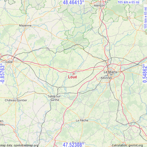
Loué GPS coordinates[2]
47° 59' 44.7" North, 0° 9' 16.2" West
| Map corner | latitude | longitude |
|---|---|---|
| Upper-left | 48.46413°, | -0.85763° |
| Center: | 47.99575°, | -0.1545° |
| Lower-right: | 47.52308°, | 0.54862° |
| Map W x H: | 104.6×104.6 km | = 65×65mi |
| max Lat: | 51.07786° ⇑40.8% North |
| Loué: | 47.99575° |
| min Lat: | ⇓59.2% South 41.3874° |
| min Long | Loué | max Long |
| -5.08615° | -0.1545° | 9.52242° |
| W 20.8%⇐ | ⇒79.2% E |
Elevation
Elevation of Loué is 77 m = 253 ft, and this is 116.7 m = 383 ft below average elevation for this country.
| Max E: |
2333 m = 7654 ft | 70.5% |
| Avg. | 193.7 m = 635 ft | |
| Loué | 77 m = 253 ft | |
Min E: |
-1 m = -3 ft | 29.5% |
See also: France elevation on elevation.city.
Geographical zone
Loué is located in North temperate zone (between Tropic of Cancer and the Arctic Circle). Distance of this North polar circle is 2064.5 km =1282.8 mi to North.| Distance of | km | miles | from Loué |
|---|---|---|---|
| North Pole | 4670.4 | 2902.1 | to North |
| Arctic Circle | 2064.5 | 1282.8 | to North |
| Tropic Cancer | 2730.7 | 1696.8 | to South |
| Equator | 5336.6 | 3316 | to South |


Nearby cities:
15 places around Loué: (largest is in red/bold)
• Bernay-en-Champagne
10.2 km =6.3 mi,  39°
39°
• Brûlon
6.7 km =4.2 mi,  241°
241°
• Chantenay-Villedieu
8.3 km =5.2 mi,  183°
183°
• Chemiré-le-Gaudin
12.7 km =7.9 mi,  125°
125°
• Coulans-sur-Gée
12.5 km =7.8 mi,  77°
77°
• Fercé-sur-Sarthe
13.9 km =8.6 mi,  138°
138°
• Joué-en-Charnie
3.6 km =2.2 mi,  312°
312°
• Louplande
9.3 km =5.8 mi,  123°
123°
• Parennes
13.9 km =8.6 mi,  350°
350°
• Poillé-sur-Vègre
11.9 km =7.4 mi,  224°
224°
• Saint-Symphorien
8.9 km =5.5 mi,  19°
19°
• Souligné-Flacé
12.7 km =7.9 mi,  100°
100°
• Tennie
13.7 km =8.5 mi,  25°
25°
• Torcé-Viviers-en-Charnie
14.3 km =8.9 mi,  324°
324°
• Vallon-sur-Gée
7.3 km =4.5 mi, 119°
Sources, notices
• [Note1] Compared only with cities in France existing in our database
• [Src1] Map data: © OpenStreetMap contributors (CC-BY-SA)
• [Src2] Other city data from geonames.org with taken over terms of usage.
• [Src3] Geographical zone / Annual Mean Temperature by Robert A. Rohde @ Wikipedia
