Pantin geodata
Pantin (Île-de-France) is a populated place; located in France in Europe/Paris (GMT+2) time zone. With population of 52,922 people, there are 111 cities with bigger population in this country. Compared to other cities in France, 77.5% of cities are located further ↓South; 51% of cities are located further →East and 79.8% of cities have higher elevation than Pantin. Note1
Administrative division(s):
- Level 1: Île-de-France
- Level 2: Seine-Saint-Denis
- Level 3: Arrondissement de Bobigny
- Level 4: Pantin


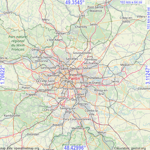
Pantin GPS coordinates[2]
48° 53' 39.732" North, 2° 24' 33.66" East
| Map corner | latitude | longitude |
|---|---|---|
| Upper-left | 49.3545°, | 1.70622° |
| Center: | 48.89437°, | 2.40935° |
| Lower-right: | 48.42996°, | 3.11247° |
| Map W x H: | 102.8×102.8 km | = 63.9×63.9mi |
| max Lat: | 51.07786° ⇑22.5% North |
| Pantin: | 48.89437° |
| min Lat: | ⇓77.5% South 41.3874° |
| min Long | Pantin | max Long |
| -5.08615° | 2.40935° | 9.52242° |
| W 49%⇐ | ⇒51% E |
Elevation
Elevation of Pantin is 55 m = 180 ft, and this is 138.7 m = 455 ft below average elevation for this country.
| Max E: |
2333 m = 7654 ft | 79.8% |
| Avg. | 193.7 m = 635 ft | |
| Pantin | 55 m = 180 ft | |
Min E: |
-1 m = -3 ft | 20.2% |
See also: Pantin elevation on elevation.city.
Geographical zone
Pantin is located in North temperate zone (between Tropic of Cancer and the Arctic Circle). Distance of this North polar circle is 1964.6 km =1220.7 mi to North.| Distance of | km | miles | from Pantin |
|---|---|---|---|
| North Pole | 4570.5 | 2840 | to North |
| Arctic Circle | 1964.6 | 1220.7 | to North |
| Tropic Cancer | 2830.6 | 1758.9 | to South |
| Equator | 5436.5 | 3378.1 | to South |


Nearby cities:
15 places around Pantin: (largest is in red/bold)
• Aubervilliers
3.1 km =1.9 mi,  322°
322°
• Bagnolet
3.1 km =1.9 mi,  170°
170°
• Bobigny
3.4 km =2.1 mi,  60°
60°
• Bondy
5.9 km =3.7 mi,  81°
81°
• Drancy
4.4 km =2.7 mi,  36°
36°
• La Courneuve
3.9 km =2.4 mi,  345°
345°
• Le Bourget
4.8 km =3 mi,  23°
23°
• Le Pré-Saint-Gervais
1.1 km =0.7 mi,  200°
200°
• Les Lilas
1.8 km =1.1 mi,  152°
152°
• Montreuil
4.2 km =2.6 mi,  143°
143°
• Noisy-le-Sec
4 km =2.5 mi,  94°
94°
• Romainville
2.1 km =1.3 mi,  118°
118°
• Saint-Denis
6.1 km =3.8 mi, 318°
• Saint-Ouen
5.7 km =3.5 mi,  283°
283°
• Vincennes
5.5 km =3.4 mi,  157°
157°
Sources, notices
• [Note1] Compared only with cities in France existing in our database
• [Src1] Map data: © OpenStreetMap contributors (CC-BY-SA)
• [Src2] Other city data from geonames.org with taken over terms of usage.
• [Src3] Geographical zone / Annual Mean Temperature by Robert A. Rohde @ Wikipedia
