Montreuil geodata
Montreuil (Île-de-France) is a populated place; located in France in Europe/Paris (GMT+2) time zone. With population of 90,652 people, there are 42 cities with bigger population in this country. Compared to other cities in France, 76.9% of cities are located further ↓South; 50.3% of cities are located further →East and 69.7% of cities have higher elevation than Montreuil. Note1
Administrative division(s):
- Level 1: Île-de-France
- Level 2: Seine-Saint-Denis
- Level 3: Arrondissement de Bobigny
- Level 4: Montreuil


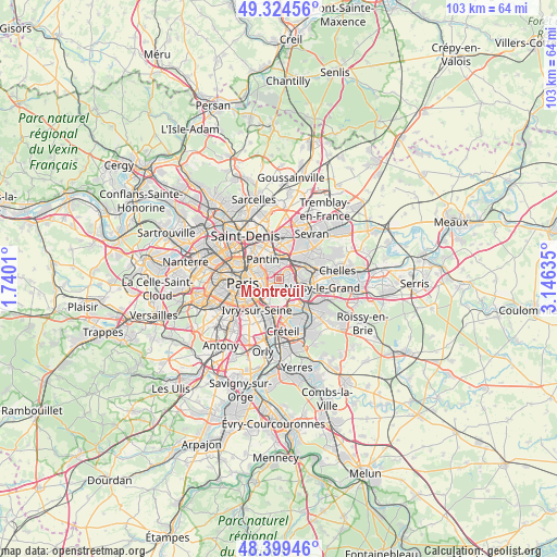
Montreuil GPS coordinates[2]
48° 51' 50.94" North, 2° 26' 35.592" East
| Map corner | latitude | longitude |
|---|---|---|
| Upper-left | 49.32456°, | 1.7401° |
| Center: | 48.86415°, | 2.44322° |
| Lower-right: | 48.39946°, | 3.14635° |
| Map W x H: | 102.9×102.9 km | = 63.9×63.9mi |
| max Lat: | 51.07786° ⇑23.1% North |
| Montreuil: | 48.86415° |
| min Lat: | ⇓76.9% South 41.3874° |
| min Long | Montreuil | max Long |
| -5.08615° | 2.44322° | 9.52242° |
| W 49.7%⇐ | ⇒50.3% E |
Elevation
Elevation of Montreuil is 79 m = 259 ft, and this is 114.7 m = 376 ft below average elevation for this country.
| Max E: |
2333 m = 7654 ft | 69.7% |
| Avg. | 193.7 m = 635 ft | |
| Montreuil | 79 m = 259 ft | |
Min E: |
-1 m = -3 ft | 30.3% |
See also: Montreuil elevation on elevation.city.
Geographical zone
Montreuil is located in North temperate zone (between Tropic of Cancer and the Arctic Circle). Distance of this North polar circle is 1968 km =1222.9 mi to North.| Distance of | km | miles | from Montreuil |
|---|---|---|---|
| North Pole | 4573.9 | 2842.1 | to North |
| Arctic Circle | 1968 | 1222.9 | to North |
| Tropic Cancer | 2827.3 | 1756.8 | to South |
| Equator | 5433.2 | 3376 | to South |


Nearby cities:
15 places around Montreuil: (largest is in red/bold)
• Bagnolet
2 km =1.2 mi,  278°
278°
• Fontenay-sous-Bois
3.1 km =1.9 mi,  110°
110°
• Joinville-le-Pont
4.9 km =3 mi,  151°
151°
• Le Perreux-sur-Marne
4.4 km =2.7 mi, 110°
• Le Pré-Saint-Gervais
3.7 km =2.3 mi,  309°
309°
• Les Lilas
2.4 km =1.5 mi,  316°
316°
• Neuilly-Plaisance
4.6 km =2.9 mi,  91°
91°
• Nogent-sur-Marne
4.2 km =2.6 mi,  136°
136°
• Noisy-le-Sec
3.4 km =2.1 mi,  27°
27°
• Pantin
4.2 km =2.6 mi, 323°
• Romainville
2.4 km =1.5 mi,  345°
345°
• Rosny-sous-Bois
4.1 km =2.5 mi,  80°
80°
• Saint-Mandé
3.5 km =2.2 mi,  215°
215°
• Villemomble
4.7 km =2.9 mi,  62°
62°
• Vincennes
1.8 km =1.1 mi,  193°
193°
Sources, notices
• [Note1] Compared only with cities in France existing in our database
• [Src1] Map data: © OpenStreetMap contributors (CC-BY-SA)
• [Src2] Other city data from geonames.org with taken over terms of usage.
• [Src3] Geographical zone / Annual Mean Temperature by Robert A. Rohde @ Wikipedia
