Saint-Denis geodata
Saint-Denis (Île-de-France) is a seat of a third-order administrative division; located in France in Europe/Paris (GMT+2) time zone. With population of 96,128 people, there are 39 cities with bigger population in this country. Compared to other cities in France, 78.3% of cities are located further ↓South; 51.8% of cities are located further →East and 89.9% of cities have higher elevation than Saint-Denis. Note1
Administrative division(s):
- Level 1: Île-de-France
- Level 2: Seine-Saint-Denis
- Level 3: Arrondissement de Saint-Denis
- Level 4: Saint-Denis


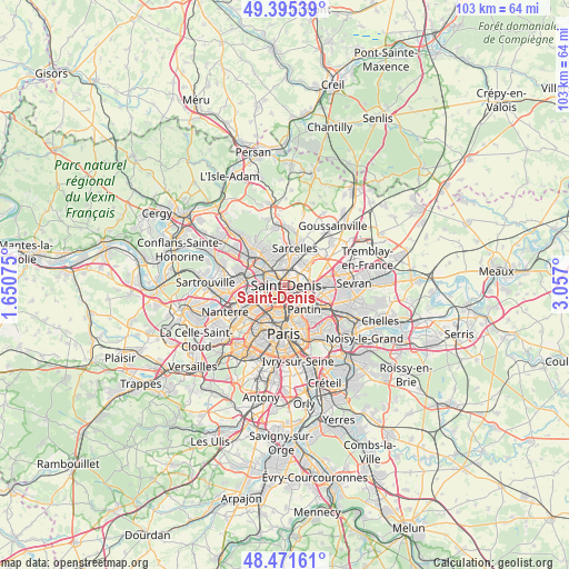
Saint-Denis GPS coordinates[2]
48° 56' 8.304" North, 2° 21' 13.932" East
| Map corner | latitude | longitude |
|---|---|---|
| Upper-left | 49.39539°, | 1.65075° |
| Center: | 48.93564°, | 2.35387° |
| Lower-right: | 48.47161°, | 3.057° |
| Map W x H: | 102.7×102.7 km | = 63.8×63.8mi |
| max Lat: | 51.07786° ⇑21.7% North |
| Saint-Denis: | 48.93564° |
| min Lat: | ⇓78.3% South 41.3874° |
| min Long | Saint-Denis | max Long |
| -5.08615° | 2.35387° | 9.52242° |
| W 48.2%⇐ | ⇒51.8% E |
Elevation
Elevation of Saint-Denis is 30 m = 98 ft, and this is 163.7 m = 537 ft below average elevation for this country.
| Max E: |
2333 m = 7654 ft | 89.9% |
| Avg. | 193.7 m = 635 ft | |
| Saint-Denis | 30 m = 98 ft | |
Min E: |
-1 m = -3 ft | 10.1% |
See also: Saint-Denis elevation on elevation.city.
Geographical zone
Saint-Denis is located in North temperate zone (between Tropic of Cancer and the Arctic Circle). Distance of this North polar circle is 1960 km =1217.9 mi to North.| Distance of | km | miles | from Saint-Denis |
|---|---|---|---|
| North Pole | 4565.9 | 2837.1 | to North |
| Arctic Circle | 1960 | 1217.9 | to North |
| Tropic Cancer | 2835.2 | 1761.7 | to South |
| Equator | 5441.1 | 3380.9 | to South |


Nearby cities:
15 places around Saint-Denis: (largest is in red/bold)
• Aubervilliers
3 km =1.9 mi,  134°
134°
• Clichy
5.1 km =3.2 mi,  219°
219°
• Deuil-la-Barre
5 km =3.1 mi,  336°
336°
• Dugny
5.1 km =3.2 mi,  66°
66°
• Enghien-les-Bains
4.4 km =2.7 mi,  321°
321°
• Garges-lès-Gonesse
4.8 km =3 mi,  41°
41°
• Gennevilliers
3.9 km =2.4 mi,  266°
266°
• La Courneuve
3.2 km =2 mi,  105°
105°
• Montmagny
4.2 km =2.6 mi,  353°
353°
• Pierrefitte-sur-Seine
3.5 km =2.2 mi,  8°
8°
• Saint-Ouen
3.6 km =2.2 mi,  204°
204°
• Stains
2.7 km =1.7 mi,  53°
53°
• Villeneuve-la-Garenne
2.9 km =1.8 mi,  278°
278°
• Villetaneuse
2.7 km =1.7 mi, 340°
• Épinay-sur-Seine
3.5 km =2.2 mi,  305°
305°
Sources, notices
• [Note1] Compared only with cities in France existing in our database
• [Src1] Map data: © OpenStreetMap contributors (CC-BY-SA)
• [Src2] Other city data from geonames.org with taken over terms of usage.
• [Src3] Geographical zone / Annual Mean Temperature by Robert A. Rohde @ Wikipedia
