Bondy geodata
Bondy (Île-de-France) is a populated place; located in France in Europe/Paris (GMT+2) time zone. With population of 48,268 people, there are 129 cities with bigger population in this country. Compared to other cities in France, 77.6% of cities are located further ↓South; 50.4% of cities are located further ←West and 81.5% of cities have higher elevation than Bondy. Note1
Administrative division(s):
- Level 1: Île-de-France
- Level 2: Seine-Saint-Denis
- Level 3: Arrondissement de Bobigny
- Level 4: Bondy


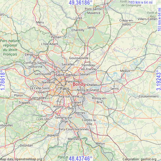
Bondy GPS coordinates[2]
48° 54' 6.48" North, 2° 29' 21.516" East
| Map corner | latitude | longitude |
|---|---|---|
| Upper-left | 49.36186°, | 1.78618° |
| Center: | 48.9018°, | 2.48931° |
| Lower-right: | 48.43746°, | 3.19243° |
| Map W x H: | 102.8×102.8 km | = 63.9×63.9mi |
| max Lat: | 51.07786° ⇑22.4% North |
| Bondy: | 48.9018° |
| min Lat: | ⇓77.6% South 41.3874° |
| min Long | Bondy | max Long |
| -5.08615° | 2.48931° | 9.52242° |
| W 50.4%⇐ | ⇒49.6% E |
Elevation
Elevation of Bondy is 51 m = 167 ft, and this is 142.7 m = 468 ft below average elevation for this country.
| Max E: |
2333 m = 7654 ft | 81.5% |
| Avg. | 193.7 m = 635 ft | |
| Bondy | 51 m = 167 ft | |
Min E: |
-1 m = -3 ft | 18.5% |
See also: Bondy elevation on elevation.city.
Geographical zone
Bondy is located in North temperate zone (between Tropic of Cancer and the Arctic Circle). Distance of this North polar circle is 1963.8 km =1220.2 mi to North.| Distance of | km | miles | from Bondy |
|---|---|---|---|
| North Pole | 4569.7 | 2839.5 | to North |
| Arctic Circle | 1963.8 | 1220.2 | to North |
| Tropic Cancer | 2831.5 | 1759.4 | to South |
| Equator | 5437.4 | 3378.6 | to South |


Nearby cities:
15 places around Bondy: (largest is in red/bold)
• Aulnay-sous-Bois
4.1 km =2.5 mi,  4°
4°
• Bobigny
3 km =1.9 mi,  287°
287°
• Clichy-sous-Bois
4.8 km =3 mi,  78°
78°
• Drancy
4.2 km =2.6 mi,  309°
309°
• Fontenay-sous-Bois
5.3 km =3.3 mi,  185°
185°
• Gagny
3.8 km =2.4 mi,  122°
122°
• Le Blanc-Mesnil
4.6 km =2.9 mi,  333°
333°
• Le Raincy
2.5 km =1.6 mi,  96°
96°
• Les Pavillons-sous-Bois
1.4 km =0.9 mi,  65°
65°
• Livry-Gargan
4.4 km =2.7 mi,  63°
63°
• Neuilly-Plaisance
4.4 km =2.7 mi,  164°
164°
• Noisy-le-Sec
2.1 km =1.3 mi,  237°
237°
• Romainville
4.4 km =2.7 mi,  245°
245°
• Rosny-sous-Bois
3.6 km =2.2 mi,  168°
168°
• Villemomble
2.2 km =1.4 mi, 159°
Sources, notices
• [Note1] Compared only with cities in France existing in our database
• [Src1] Map data: © OpenStreetMap contributors (CC-BY-SA)
• [Src2] Other city data from geonames.org with taken over terms of usage.
• [Src3] Geographical zone / Annual Mean Temperature by Robert A. Rohde @ Wikipedia
