Ostricourt geodata
Ostricourt (Hauts-de-France) is a populated place; located in France in Europe/Paris (GMT+2) time zone. With population of 5,522 people, there are 1794 cities with bigger population in this country. Compared to other cities in France, 96.9% of cities are located further ↓South; 58.3% of cities are located further ←West and 90.3% of cities have higher elevation than Ostricourt. Note1
Administrative division(s):
- Level 1: Hauts-de-France
- Level 2: Nord
- Level 3: Arrondissement de Lille
- Level 4: Ostricourt


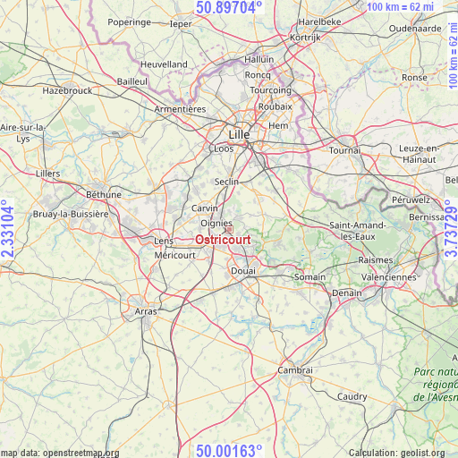
Ostricourt GPS coordinates[2]
50° 27' 5.22" North, 3° 2' 3.012" East
| Map corner | latitude | longitude |
|---|---|---|
| Upper-left | 50.89704°, | 2.33104° |
| Center: | 50.45145°, | 3.03417° |
| Lower-right: | 50.00163°, | 3.73729° |
| Map W x H: | 99.6×99.6 km | = 61.9×61.9mi |
| max Lat: | 51.07786° ⇑3.1% North |
| Ostricourt: | 50.45145° |
| min Lat: | ⇓96.9% South 41.3874° |
| min Long | Ostricourt | max Long |
| -5.08615° | 3.03417° | 9.52242° |
| W 58.3%⇐ | ⇒41.7% E |
Elevation
Elevation of Ostricourt is 29 m = 95 ft, and this is 164.7 m = 540 ft below average elevation for this country.
| Max E: |
2333 m = 7654 ft | 90.3% |
| Avg. | 193.7 m = 635 ft | |
| Ostricourt | 29 m = 95 ft | |
Min E: |
-1 m = -3 ft | 9.7% |
See also: France elevation on elevation.city.
Geographical zone
Ostricourt is located in North temperate zone (between Tropic of Cancer and the Arctic Circle). Distance of this North polar circle is 1791.5 km =1113.2 mi to North.| Distance of | km | miles | from Ostricourt |
|---|---|---|---|
| North Pole | 4397.4 | 2732.4 | to North |
| Arctic Circle | 1791.5 | 1113.2 | to North |
| Tropic Cancer | 3003.8 | 1866.5 | to South |
| Equator | 5609.7 | 3485.7 | to South |


Nearby cities:
15 places around Ostricourt: (largest is in red/bold)
• Auby
4.3 km =2.7 mi,  161°
161°
• Courcelles-lès-Lens
4.1 km =2.5 mi,  197°
197°
• Dourges
3.8 km =2.4 mi,  243°
243°
• Flers-en-Escrebieux
6.2 km =3.9 mi, 162°
• La Neuville
4.7 km =2.9 mi,  12°
12°
• Leforest
2.6 km =1.6 mi,  123°
123°
• Libercourt
3.8 km =2.4 mi,  339°
339°
• Mons-en-Pévèle
5.5 km =3.4 mi,  55°
55°
• Noyelles-Godault
4.8 km =3 mi,  217°
217°
• Oignies
3.1 km =1.9 mi,  294°
294°
• Raimbeaucourt
4.6 km =2.9 mi,  114°
114°
• Roost-Warendin
6.1 km =3.8 mi,  126°
126°
• Thumeries
3.2 km =2 mi,  27°
27°
• Wahagnies
3.9 km =2.4 mi,  0°
0°
• Évin-Malmaison
1.4 km =0.9 mi,  188°
188°
Sources, notices
• [Note1] Compared only with cities in France existing in our database
• [Src1] Map data: © OpenStreetMap contributors (CC-BY-SA)
• [Src2] Other city data from geonames.org with taken over terms of usage.
• [Src3] Geographical zone / Annual Mean Temperature by Robert A. Rohde @ Wikipedia
