Leforest geodata
Leforest (Hauts-de-France) is a populated place; located in France in Europe/Paris (GMT+2) time zone. With population of 6,843 people, there are 1444 cities with bigger population in this country. Compared to other cities in France, 96.8% of cities are located further ↓South; 58.7% of cities are located further ←West and 90.7% of cities have higher elevation than Leforest. Note1
Administrative division(s):
- Level 1: Hauts-de-France
- Level 2: Pas-de-Calais
- Level 3: Arrondissement de Lens
- Level 4: Leforest


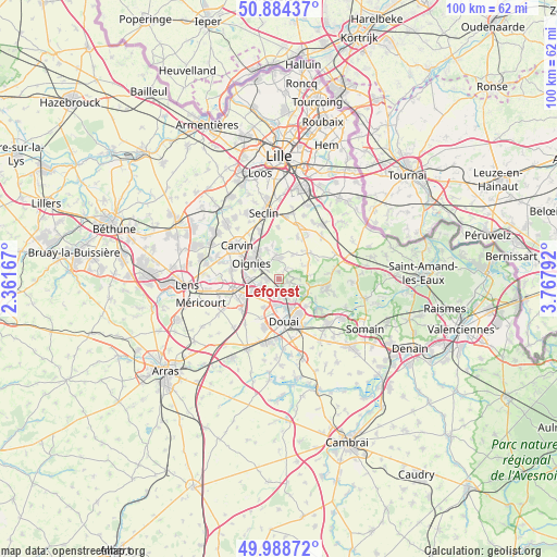
Leforest GPS coordinates[2]
50° 26' 19.176" North, 3° 3' 53.28" East
| Map corner | latitude | longitude |
|---|---|---|
| Upper-left | 50.88437°, | 2.36167° |
| Center: | 50.43866°, | 3.0648° |
| Lower-right: | 49.98872°, | 3.76792° |
| Map W x H: | 99.6×99.6 km | = 61.9×61.9mi |
| max Lat: | 51.07786° ⇑3.2% North |
| Leforest: | 50.43866° |
| min Lat: | ⇓96.8% South 41.3874° |
| min Long | Leforest | max Long |
| -5.08615° | 3.0648° | 9.52242° |
| W 58.7%⇐ | ⇒41.3% E |
Elevation
Elevation of Leforest is 28 m = 92 ft, and this is 165.7 m = 544 ft below average elevation for this country.
| Max E: |
2333 m = 7654 ft | 90.7% |
| Avg. | 193.7 m = 635 ft | |
| Leforest | 28 m = 92 ft | |
Min E: |
-1 m = -3 ft | 9.3% |
See also: France elevation on elevation.city.
Geographical zone
Leforest is located in North temperate zone (between Tropic of Cancer and the Arctic Circle). Distance of this North polar circle is 1792.9 km =1114.1 mi to North.| Distance of | km | miles | from Leforest |
|---|---|---|---|
| North Pole | 4398.8 | 2733.3 | to North |
| Arctic Circle | 1792.9 | 1114.1 | to North |
| Tropic Cancer | 3002.3 | 1865.5 | to South |
| Equator | 5608.3 | 3484.8 | to South |


Nearby cities:
15 places around Leforest: (largest is in red/bold)
• Auby
2.8 km =1.7 mi,  195°
195°
• Courcelles-lès-Lens
4.2 km =2.6 mi,  234°
234°
• Dourges
5.6 km =3.5 mi,  267°
267°
• Faumont
5.7 km =3.5 mi,  64°
64°
• Flers-en-Escrebieux
4.5 km =2.8 mi,  183°
183°
• Lauwin-Planque
5.6 km =3.5 mi,  194°
194°
• Mons-en-Pévèle
5.1 km =3.2 mi,  27°
27°
• Noyelles-Godault
5.6 km =3.5 mi,  245°
245°
• Oignies
5.7 km =3.5 mi,  298°
298°
• Ostricourt
2.6 km =1.6 mi, 303°
• Raimbeaucourt
2.1 km =1.3 mi,  102°
102°
• Roost-Warendin
3.5 km =2.2 mi,  128°
128°
• Râches
5.6 km =3.5 mi,  115°
115°
• Thumeries
4.3 km =2.7 mi,  350°
350°
• Évin-Malmaison
2.4 km =1.5 mi, 271°
Sources, notices
• [Note1] Compared only with cities in France existing in our database
• [Src1] Map data: © OpenStreetMap contributors (CC-BY-SA)
• [Src2] Other city data from geonames.org with taken over terms of usage.
• [Src3] Geographical zone / Annual Mean Temperature by Robert A. Rohde @ Wikipedia
