Roost-Warendin geodata
Roost-Warendin (Hauts-de-France) is a populated place; located in France in Europe/Paris (GMT+2) time zone. With population of 5,875 people, there are 1684 cities with bigger population in this country. Compared to other cities in France, 96.6% of cities are located further ↓South; 59.4% of cities are located further ←West and 94.4% of cities have higher elevation than Roost-Warendin. Note1
Administrative division(s):
- Level 1: Hauts-de-France
- Level 2: Nord
- Level 3: Arrondissement de Douai
- Level 4: Roost-Warendin


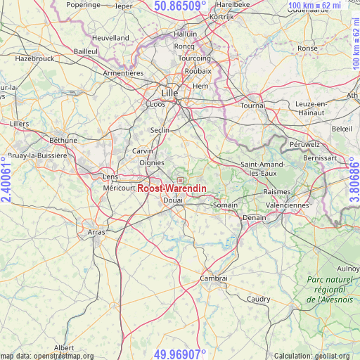
Roost-Warendin GPS coordinates[2]
50° 25' 9.12" North, 3° 6' 13.464" East
| Map corner | latitude | longitude |
|---|---|---|
| Upper-left | 50.86509°, | 2.40061° |
| Center: | 50.4192°, | 3.10374° |
| Lower-right: | 49.96907°, | 3.80686° |
| Map W x H: | 99.6×99.6 km | = 61.9×61.9mi |
| max Lat: | 51.07786° ⇑3.4% North |
| Roost-Warendin: | 50.4192° |
| min Lat: | ⇓96.6% South 41.3874° |
| min Long | Roost-Warendin | max Long |
| -5.08615° | 3.10374° | 9.52242° |
| W 59.4%⇐ | ⇒40.6% E |
Elevation
Elevation of Roost-Warendin is 19 m = 62 ft, and this is 174.7 m = 573 ft below average elevation for this country.
| Max E: |
2333 m = 7654 ft | 94.4% |
| Avg. | 193.7 m = 635 ft | |
| Roost-Warendin | 19 m = 62 ft | |
Min E: |
-1 m = -3 ft | 5.6% |
See also: France elevation on elevation.city.
Geographical zone
Roost-Warendin is located in North temperate zone (between Tropic of Cancer and the Arctic Circle). Distance of this North polar circle is 1795.1 km =1115.4 mi to North.| Distance of | km | miles | from Roost-Warendin |
|---|---|---|---|
| North Pole | 4401 | 2734.7 | to North |
| Arctic Circle | 1795.1 | 1115.4 | to North |
| Tropic Cancer | 3000.2 | 1864.2 | to South |
| Equator | 5606.1 | 3483.5 | to South |


Nearby cities:
15 places around Roost-Warendin: (largest is in red/bold)
• Anhiers
3.9 km =2.4 mi,  109°
109°
• Auby
3.6 km =2.2 mi,  261°
261°
• Cuincy
5.7 km =3.5 mi,  219°
219°
• Douai
5.7 km =3.5 mi,  197°
197°
• Faumont
5.1 km =3.2 mi,  27°
27°
• Flers-en-Escrebieux
3.9 km =2.4 mi,  232°
232°
• Flines-lez-Raches
5.6 km =3.5 mi,  92°
92°
• Lallaing
5.7 km =3.5 mi,  124°
124°
• Lauwin-Planque
5.3 km =3.3 mi, 232°
• Leforest
3.5 km =2.2 mi,  308°
308°
• Ostricourt
6.1 km =3.8 mi, 306°
• Raimbeaucourt
1.9 km =1.2 mi,  336°
336°
• Râches
2.3 km =1.4 mi,  95°
95°
• Waziers
3.6 km =2.2 mi,  167°
167°
• Évin-Malmaison
5.6 km =3.5 mi,  293°
293°
Sources, notices
• [Note1] Compared only with cities in France existing in our database
• [Src1] Map data: © OpenStreetMap contributors (CC-BY-SA)
• [Src2] Other city data from geonames.org with taken over terms of usage.
• [Src3] Geographical zone / Annual Mean Temperature by Robert A. Rohde @ Wikipedia
