Orgères-en-Beauce geodata
Orgères-en-Beauce (Centre) is a populated place; located in France in Europe/Paris (GMT+2) time zone. With population of 1,072 people, there are 8316 cities with bigger population in this country. Compared to other cities in France, 62% of cities are located further ↓South; 60.6% of cities are located further →East and 50.5% of cities have higher elevation than Orgères-en-Beauce. Note1
Administrative division(s):
- Level 1: Centre
- Level 2: Département d'Eure-et-Loir
- Level 3: Arrondissement de Châteaudun
- Level 4: Orgères-en-Beauce


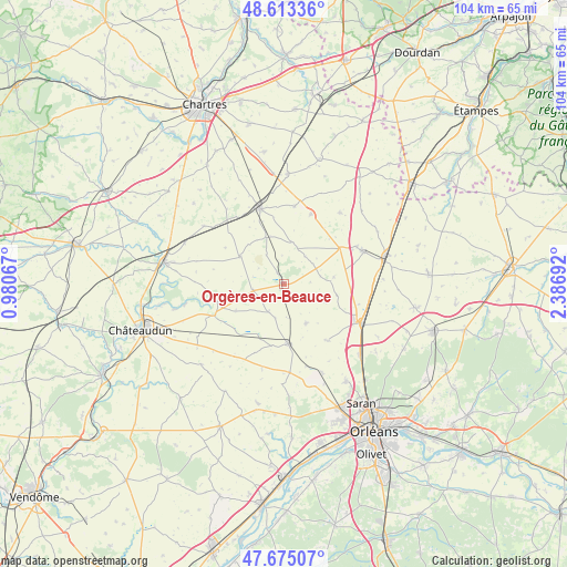
Orgères-en-Beauce GPS coordinates[2]
48° 8' 46.896" North, 1° 41' 1.68" East
| Map corner | latitude | longitude |
|---|---|---|
| Upper-left | 48.61336°, | 0.98067° |
| Center: | 48.14636°, | 1.6838° |
| Lower-right: | 47.67507°, | 2.38692° |
| Map W x H: | 104.3×104.3 km | = 64.8×64.8mi |
| max Lat: | 51.07786° ⇑38% North |
| Orgères-en-Beauce: | 48.14636° |
| min Lat: | ⇓62% South 41.3874° |
| min Long | Orgères-en-Bea | max Long |
| -5.08615° | 1.6838° | 9.52242° |
| W 39.4%⇐ | ⇒60.6% E |
Elevation
Elevation of Orgères-en-Beauce is 130 m = 427 ft, and this is 63.7 m = 209 ft below average elevation for this country.
| Max E: |
2333 m = 7654 ft | 50.5% |
| Avg. | 193.7 m = 635 ft | |
| Orgères-en-Beauce | 130 m = 427 ft | |
Min E: |
-1 m = -3 ft | 49.5% |
See also: France elevation on elevation.city.
Geographical zone
Orgères-en-Beauce is located in North temperate zone (between Tropic of Cancer and the Arctic Circle). Distance of this North polar circle is 2047.8 km =1272.4 mi to North.| Distance of | km | miles | from Orgères-en-Beauce |
|---|---|---|---|
| North Pole | 4653.7 | 2891.7 | to North |
| Arctic Circle | 2047.8 | 1272.4 | to North |
| Tropic Cancer | 2747.5 | 1707.2 | to South |
| Equator | 5353.4 | 3326.4 | to South |


Nearby cities:
15 places around Orgères-en-Beauce: (largest is in red/bold)
• Artenay
16.3 km =10.1 mi,  115°
115°
• Baigneaux
10 km =6.2 mi,  98°
98°
• Boisville-la-Saint-Père
20.3 km =12.6 mi,  1°
1°
• Boulay-les-Barres
19.5 km =12.1 mi,  157°
157°
• Bricy
17.9 km =11.1 mi, 156°
• Chevilly
19.2 km =11.9 mi,  132°
132°
• Janville
15.9 km =9.9 mi,  66°
66°
• Le Gault-Saint-Denis
17.7 km =11 mi,  303°
303°
• Patay
10.9 km =6.8 mi,  175°
175°
• Saint-Péravy-la-Colombe
16.5 km =10.3 mi, 175°
• Sancheville
9.4 km =5.8 mi, 303°
• Sougy
12.9 km =8 mi,  143°
143°
• Terminiers
8.3 km =5.2 mi,  148°
148°
• Toury
19.4 km =12.1 mi, 74°
• Voves
14.5 km =9 mi,  342°
342°
Sources, notices
• [Note1] Compared only with cities in France existing in our database
• [Src1] Map data: © OpenStreetMap contributors (CC-BY-SA)
• [Src2] Other city data from geonames.org with taken over terms of usage.
• [Src3] Geographical zone / Annual Mean Temperature by Robert A. Rohde @ Wikipedia
