Romagnat geodata
Romagnat (Auvergne-Rhône-Alpes) is a populated place; located in France in Europe/Paris (GMT+2) time zone. With population of 8,771 people, there are 1093 cities with bigger population in this country. Compared to other cities in France, 70.4% of cities are located further ↑North; 59.3% of cities are located further ←West and 94.8% of cities have lower elevation than Romagnat. Note1
Administrative division(s):
- Level 1: Auvergne-Rhône-Alpes
- Level 2: Département du Puy-de-Dôme
- Level 3: Arrondissement de Clermont-Ferrand
- Level 4: Romagnat


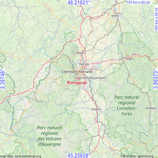
Romagnat GPS coordinates[2]
45° 43' 46.38" North, 3° 6' 2.196" East
| Map corner | latitude | longitude |
|---|---|---|
| Upper-left | 46.21821°, | 2.39748° |
| Center: | 45.72955°, | 3.10061° |
| Lower-right: | 45.23658°, | 3.80373° |
| Map W x H: | 109.1×109.1 km | = 67.8×67.8mi |
| max Lat: | 51.07786° ⇑70.4% North |
| Romagnat: | 45.72955° |
| min Lat: | ⇓29.6% South 41.3874° |
| min Long | Romagnat | max Long |
| -5.08615° | 3.10061° | 9.52242° |
| W 59.3%⇐ | ⇒40.7% E |
Elevation
Elevation of Romagnat is 575 m = 1886 ft, and this is 381.3 m = 1251 ft above average elevation for this country.
| Max E: |
2333 m = 7654 ft | 5.2% |
| Romagnat | 575 m 1886 ft | |
| Avg. | 193.7 m = 635 ft | |
Min E: |
-1 m = -3 ft | 94.8% |
See also: France elevation on elevation.city.
Geographical zone
Romagnat is located in North temperate zone (between Tropic of Cancer and the Arctic Circle). Distance of this North polar circle is 2316.5 km =1439.4 mi to North.| Distance of | km | miles | from Romagnat |
|---|---|---|---|
| North Pole | 4922.4 | 3058.6 | to North |
| Arctic Circle | 2316.5 | 1439.4 | to North |
| Tropic Cancer | 2478.7 | 1540.2 | to South |
| Equator | 5084.6 | 3159.4 | to South |


Nearby cities:
15 places around Romagnat: (largest is in red/bold)
• Aubière
2.5 km =1.6 mi,  18°
18°
• Beaumont
2.8 km =1.7 mi,  330°
330°
• Ceyrat
2.9 km =1.8 mi,  276°
276°
• Chamalières
5.6 km =3.5 mi, 332°
• Chanonat
4.1 km =2.5 mi,  187°
187°
• Clermont-Ferrand
5.7 km =3.5 mi,  349°
349°
• La Roche-Blanche
3.8 km =2.4 mi,  148°
148°
• Le Cendre
6.8 km =4.2 mi,  96°
96°
• Le Crest
5.2 km =3.2 mi,  156°
156°
• Orcet
6 km =3.7 mi,  118°
118°
• Pérignat-lès-Sarliève
3.1 km =1.9 mi,  75°
75°
• Royat
5.6 km =3.5 mi,  315°
315°
• Saint-Amant-Tallende
6.8 km =4.2 mi,  175°
175°
• Saint-Genès-Champanelle
6.4 km =4 mi,  260°
260°
• Tallende
6.8 km =4.2 mi, 164°
Sources, notices
• [Note1] Compared only with cities in France existing in our database
• [Src1] Map data: © OpenStreetMap contributors (CC-BY-SA)
• [Src2] Other city data from geonames.org with taken over terms of usage.
• [Src3] Geographical zone / Annual Mean Temperature by Robert A. Rohde @ Wikipedia
