Omissy geodata
Omissy (Hauts-de-France) is a populated place; located in France in Europe/Paris (GMT+2) time zone. With population of 1,078 people, there are 8272 cities with bigger population in this country. Compared to other cities in France, 92.8% of cities are located further ↓South; 62.2% of cities are located further ←West and 70.5% of cities have higher elevation than Omissy. Note1
Administrative division(s):
- Level 1: Hauts-de-France
- Level 2: Département de l'Aisne
- Level 3: Arrondissement de Saint-Quentin
- Level 4: Omissy


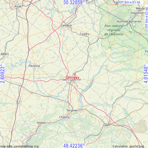
Omissy GPS coordinates[2]
49° 52' 39.36" North, 3° 18' 44.46" East
| Map corner | latitude | longitude |
|---|---|---|
| Upper-left | 50.32859°, | 2.60923° |
| Center: | 49.8776°, | 3.31235° |
| Lower-right: | 49.42236°, | 4.01548° |
| Map W x H: | 100.8×100.8 km | = 62.6×62.6mi |
| max Lat: | 51.07786° ⇑7.2% North |
| Omissy: | 49.8776° |
| min Lat: | ⇓92.8% South 41.3874° |
| min Long | Omissy | max Long |
| -5.08615° | 3.31235° | 9.52242° |
| W 62.2%⇐ | ⇒37.8% E |
Elevation
Elevation of Omissy is 77 m = 253 ft, and this is 116.7 m = 383 ft below average elevation for this country.
| Max E: |
2333 m = 7654 ft | 70.5% |
| Avg. | 193.7 m = 635 ft | |
| Omissy | 77 m = 253 ft | |
Min E: |
-1 m = -3 ft | 29.5% |
See also: France elevation on elevation.city.
Geographical zone
Omissy is located in North temperate zone (between Tropic of Cancer and the Arctic Circle). Distance of this North polar circle is 1855.3 km =1152.8 mi to North.| Distance of | km | miles | from Omissy |
|---|---|---|---|
| North Pole | 4461.2 | 2772.1 | to North |
| Arctic Circle | 1855.3 | 1152.8 | to North |
| Tropic Cancer | 2940 | 1826.8 | to South |
| Equator | 5545.9 | 3446.1 | to South |


Nearby cities:
15 places around Omissy: (largest is in red/bold)
• Fayet
4.4 km =2.7 mi,  256°
256°
• Fonsomme
6.8 km =4.2 mi,  68°
68°
• Gauchy
6.2 km =3.9 mi,  206°
206°
• Gricourt
5 km =3.1 mi,  282°
282°
• Grugies
7.9 km =4.9 mi,  203°
203°
• Harly
4.4 km =2.7 mi,  182°
182°
• Holnon
7.2 km =4.5 mi, 255°
• Homblières
4.8 km =3 mi,  129°
129°
• Itancourt
8.2 km =5.1 mi,  163°
163°
• Lesdins
2.6 km =1.6 mi,  30°
30°
• Levergies
5.4 km =3.4 mi,  359°
359°
• Morcourt
0.8 km =0.5 mi,  112°
112°
• Nauroy
9.4 km =5.8 mi,  334°
334°
• Neuville-Saint-Amand
6 km =3.7 mi, 164°
• Saint-Quentin
3.7 km =2.3 mi, 209°
Sources, notices
• [Note1] Compared only with cities in France existing in our database
• [Src1] Map data: © OpenStreetMap contributors (CC-BY-SA)
• [Src2] Other city data from geonames.org with taken over terms of usage.
• [Src3] Geographical zone / Annual Mean Temperature by Robert A. Rohde @ Wikipedia
