Levergies geodata
Levergies (Hauts-de-France) is a populated place; located in France in Europe/Paris (GMT+2) time zone. With population of 588 people, there are 13513 cities with bigger population in this country. Compared to other cities in France, 93.1% of cities are located further ↓South; 62.2% of cities are located further ←West and 56.2% of cities have higher elevation than Levergies. Note1
Administrative division(s):
- Level 1: Hauts-de-France
- Level 2: Département de l'Aisne
- Level 3: Arrondissement de Saint-Quentin
- Level 4: Levergies


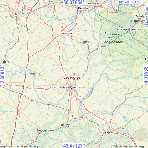
Levergies GPS coordinates[2]
49° 55' 33.636" North, 3° 18' 44.1" East
| Map corner | latitude | longitude |
|---|---|---|
| Upper-left | 50.37654°, | 2.60913° |
| Center: | 49.92601°, | 3.31225° |
| Lower-right: | 49.47123°, | 4.01538° |
| Map W x H: | 100.7×100.7 km | = 62.6×62.6mi |
| max Lat: | 51.07786° ⇑6.9% North |
| Levergies: | 49.92601° |
| min Lat: | ⇓93.1% South 41.3874° |
| min Long | Levergies | max Long |
| -5.08615° | 3.31225° | 9.52242° |
| W 62.2%⇐ | ⇒37.8% E |
Elevation
Elevation of Levergies is 113 m = 371 ft, and this is 80.7 m = 265 ft below average elevation for this country.
| Max E: |
2333 m = 7654 ft | 56.2% |
| Avg. | 193.7 m = 635 ft | |
| Levergies | 113 m = 371 ft | |
Min E: |
-1 m = -3 ft | 43.8% |
See also: France elevation on elevation.city.
Geographical zone
Levergies is located in North temperate zone (between Tropic of Cancer and the Arctic Circle). Distance of this North polar circle is 1849.9 km =1149.5 mi to North.| Distance of | km | miles | from Levergies |
|---|---|---|---|
| North Pole | 4455.8 | 2768.7 | to North |
| Arctic Circle | 1849.9 | 1149.5 | to North |
| Tropic Cancer | 2945.3 | 1830.1 | to South |
| Equator | 5551.3 | 3449.4 | to South |


Nearby cities:
15 places around Levergies: (largest is in red/bold)
• Beaurevoir
7.9 km =4.9 mi,  358°
358°
• Bellicourt
6.8 km =4.2 mi,  305°
305°
• Brancourt-le-Grand
7.5 km =4.7 mi,  41°
41°
• Fayet
7.7 km =4.8 mi,  213°
213°
• Fonsomme
6.9 km =4.3 mi,  114°
114°
• Fresnoy-le-Grand
8 km =5 mi,  72°
72°
• Gouy
9.3 km =5.8 mi,  334°
334°
• Gricourt
6.5 km =4 mi,  228°
228°
• Homblières
9.2 km =5.7 mi,  156°
156°
• Lesdins
3.5 km =2.2 mi, 157°
• Montbrehain
5.2 km =3.2 mi,  30°
30°
• Morcourt
5.7 km =3.5 mi,  172°
172°
• Nauroy
5.1 km =3.2 mi, 306°
• Omissy
5.4 km =3.4 mi,  179°
179°
• Saint-Quentin
8.8 km =5.5 mi,  191°
191°
Sources, notices
• [Note1] Compared only with cities in France existing in our database
• [Src1] Map data: © OpenStreetMap contributors (CC-BY-SA)
• [Src2] Other city data from geonames.org with taken over terms of usage.
• [Src3] Geographical zone / Annual Mean Temperature by Robert A. Rohde @ Wikipedia
