Fonsomme geodata
Fonsomme (Hauts-de-France) is a populated place; located in France in Europe/Paris (GMT+2) time zone. With population of 557 people, there are 14072 cities with bigger population in this country. Compared to other cities in France, 93% of cities are located further ↓South; 63.2% of cities are located further ←West and 64% of cities have higher elevation than Fonsomme. Note1
Administrative division(s):
- Level 1: Hauts-de-France
- Level 2: Département de l'Aisne
- Level 3: Arrondissement de Saint-Quentin
- Level 4: Fonsomme


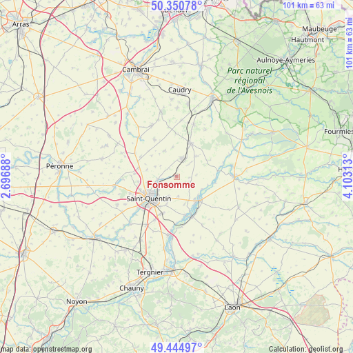
Fonsomme GPS coordinates[2]
49° 54' 0" North, 3° 24' 0" East
| Map corner | latitude | longitude |
|---|---|---|
| Upper-left | 50.35078°, | 2.69688° |
| Center: | 49.9°, | 3.4° |
| Lower-right: | 49.44497°, | 4.10313° |
| Map W x H: | 100.7×100.7 km | = 62.6×62.6mi |
| max Lat: | 51.07786° ⇑7% North |
| Fonsomme: | 49.9° |
| min Lat: | ⇓93% South 41.3874° |
| min Long | Fonsomme | max Long |
| -5.08615° | 3.4° | 9.52242° |
| W 63.2%⇐ | ⇒36.8% E |
Elevation
Elevation of Fonsomme is 92 m = 302 ft, and this is 101.7 m = 334 ft below average elevation for this country.
| Max E: |
2333 m = 7654 ft | 64% |
| Avg. | 193.7 m = 635 ft | |
| Fonsomme | 92 m = 302 ft | |
Min E: |
-1 m = -3 ft | 36% |
See also: France elevation on elevation.city.
Geographical zone
Fonsomme is located in North temperate zone (between Tropic of Cancer and the Arctic Circle). Distance of this North polar circle is 1852.8 km =1151.3 mi to North.| Distance of | km | miles | from Fonsomme |
|---|---|---|---|
| North Pole | 4458.7 | 2770.5 | to North |
| Arctic Circle | 1852.8 | 1151.3 | to North |
| Tropic Cancer | 2942.4 | 1828.3 | to South |
| Equator | 5548.4 | 3447.6 | to South |


Nearby cities:
15 places around Fonsomme: (largest is in red/bold)
• Brancourt-le-Grand
8.6 km =5.3 mi,  351°
351°
• Fresnoy-le-Grand
5.5 km =3.4 mi,  13°
13°
• Harly
9.5 km =5.9 mi,  222°
222°
• Homblières
6.1 km =3.8 mi,  204°
204°
• Lesdins
5 km =3.1 mi,  266°
266°
• Levergies
6.9 km =4.3 mi,  294°
294°
• Montbrehain
8.3 km =5.2 mi,  333°
333°
• Morcourt
6.2 km =3.9 mi,  243°
243°
• Neuville-Saint-Amand
9.5 km =5.9 mi,  209°
209°
• Omissy
6.8 km =4.2 mi,  248°
248°
• Origny-Sainte-Benoite
10.3 km =6.4 mi,  135°
135°
• Saint-Quentin
9.9 km =6.2 mi,  234°
234°
• Seboncourt
8 km =5 mi,  42°
42°
• Thenelles
9.1 km =5.7 mi,  148°
148°
• Étaves-et-Bocquiaux
5.9 km =3.7 mi, 42°
Sources, notices
• [Note1] Compared only with cities in France existing in our database
• [Src1] Map data: © OpenStreetMap contributors (CC-BY-SA)
• [Src2] Other city data from geonames.org with taken over terms of usage.
• [Src3] Geographical zone / Annual Mean Temperature by Robert A. Rohde @ Wikipedia
