Olonne-sur-Mer geodata
Olonne-sur-Mer (Pays de la Loire) is a populated place; located in France in Europe/Paris (GMT+2) time zone. With population of 11,157 people, there are 859 cities with bigger population in this country. Compared to other cities in France, 59.8% of cities are located further ↑North; 93.9% of cities are located further →East and 92.4% of cities have higher elevation than Olonne-sur-Mer. Note1
Administrative division(s):
- Level 1: Pays de la Loire
- Level 2: Département de la Vendée
- Level 3: Arrondissement des Sables-d'Olonne
- Level 4: Les Sables-d'Olonne


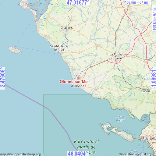
Olonne-sur-Mer GPS coordinates[2]
46° 32' 6.864" North, 1° 46' 22.548" West
| Map corner | latitude | longitude |
|---|---|---|
| Upper-left | 47.01677°, | -2.47606° |
| Center: | 46.53524°, | -1.77293° |
| Lower-right: | 46.0494°, | -1.06981° |
| Map W x H: | 107.6×107.6 km | = 66.9×66.9mi |
| max Lat: | 51.07786° ⇑59.8% North |
| Olonne-sur-Mer: | 46.53524° |
| min Lat: | ⇓40.2% South 41.3874° |
| min Long | Olonne-sur-Mer | max Long |
| -5.08615° | -1.77293° | 9.52242° |
| W 6.1%⇐ | ⇒93.9% E |
Elevation
Elevation of Olonne-sur-Mer is 24 m = 79 ft, and this is 169.7 m = 557 ft below average elevation for this country.
| Max E: |
2333 m = 7654 ft | 92.4% |
| Avg. | 193.7 m = 635 ft | |
| Olonne-sur-Mer | 24 m = 79 ft | |
Min E: |
-1 m = -3 ft | 7.6% |
See also: France elevation on elevation.city.
Geographical zone
Olonne-sur-Mer is located in North temperate zone (between Tropic of Cancer and the Arctic Circle). Distance of this North polar circle is 2226.9 km =1383.7 mi to North.| Distance of | km | miles | from Olonne-sur-Mer |
|---|---|---|---|
| North Pole | 4832.8 | 3003 | to North |
| Arctic Circle | 2226.9 | 1383.7 | to North |
| Tropic Cancer | 2568.3 | 1595.9 | to South |
| Equator | 5174.2 | 3215.1 | to South |


Nearby cities:
15 places around Olonne-sur-Mer: (largest is in red/bold)
• Bretignolles-sur-Mer
13 km =8.1 mi,  326°
326°
• Château-d’Olonne
4.3 km =2.7 mi,  145°
145°
• Grosbreuil
12 km =7.5 mi,  87°
87°
• La Chaize-Giraud
12.9 km =8 mi,  344°
344°
• La Chapelle-Achard
11.3 km =7 mi,  58°
58°
• La Chapelle-Hermier
16.8 km =10.4 mi,  13°
13°
• La Mothe-Achard
12.5 km =7.8 mi,  44°
44°
• Landevieille
12.1 km =7.5 mi,  347°
347°
• Le Girouard
13.8 km =8.6 mi,  74°
74°
• Les Sables-d’Olonne
4.4 km =2.7 mi,  191°
191°
• Saint-Hilaire-de-Talmont
14.9 km =9.3 mi,  119°
119°
• Saint-Julien-des-Landes
12.4 km =7.7 mi,  21°
21°
• Saint-Mathurin
5.6 km =3.5 mi,  53°
53°
• Sainte-Foy
7.7 km =4.8 mi,  82°
82°
• Vairé
7.4 km =4.6 mi, 10°
Sources, notices
• [Note1] Compared only with cities in France existing in our database
• [Src1] Map data: © OpenStreetMap contributors (CC-BY-SA)
• [Src2] Other city data from geonames.org with taken over terms of usage.
• [Src3] Geographical zone / Annual Mean Temperature by Robert A. Rohde @ Wikipedia
