Les Sables-d’Olonne geodata
Les Sables-d’Olonne (Pays de la Loire) is a seat of a third-order administrative division; located in France in Europe/Paris (GMT+2) time zone. With population of 16,105 people, there are 589 cities with bigger population in this country. Compared to other cities in France, 60.1% of cities are located further ↑North; 94% of cities are located further →East and 99.3% of cities have higher elevation than Les Sables-d’Olonne. Note1
Administrative division(s):
- Level 1: Pays de la Loire
- Level 2: Département de la Vendée
- Level 3: Arrondissement des Sables-d'Olonne
- Level 4: Les Sables-d'Olonne


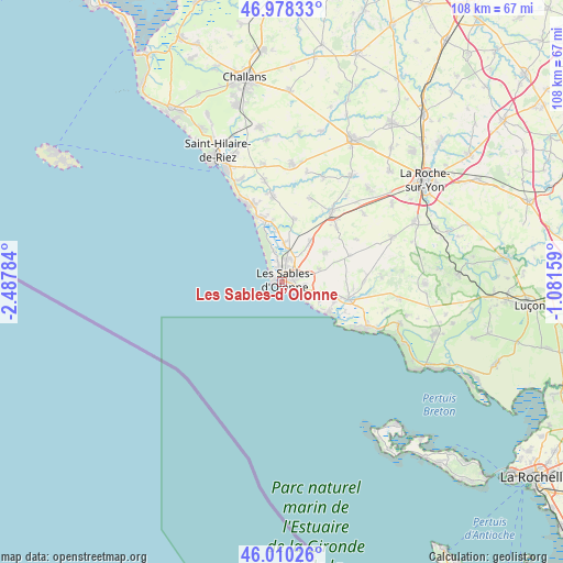
Les Sables-d’Olonne GPS coordinates[2]
46° 29' 47.22" North, 1° 47' 4.992" West
| Map corner | latitude | longitude |
|---|---|---|
| Upper-left | 46.97833°, | -2.48784° |
| Center: | 46.49645°, | -1.78472° |
| Lower-right: | 46.01026°, | -1.08159° |
| Map W x H: | 107.6×107.6 km | = 66.9×66.9mi |
| max Lat: | 51.07786° ⇑60.1% North |
| Les Sables-d’Olonne: | 46.49645° |
| min Lat: | ⇓39.9% South 41.3874° |
| min Long | Les Sables-d’ | max Long |
| -5.08615° | -1.78472° | 9.52242° |
| W 6%⇐ | ⇒94% E |
Elevation
Elevation of Les Sables-d’Olonne is 5 m = 16 ft, and this is 188.7 m = 619 ft below average elevation for this country.
| Max E: |
2333 m = 7654 ft | 99.3% |
| Avg. | 193.7 m = 635 ft | |
| Les Sables-d’Olonne | 5 m = 16 ft | |
Min E: |
-1 m = -3 ft | 0.7% |
See also: France elevation on elevation.city.
Geographical zone
Les Sables-d’Olonne is located in North temperate zone (between Tropic of Cancer and the Arctic Circle). Distance of this North polar circle is 2231.3 km =1386.5 mi to North.| Distance of | km | miles | from Les Sables-d’Olonne |
|---|---|---|---|
| North Pole | 4837.1 | 3005.6 | to North |
| Arctic Circle | 2231.3 | 1386.5 | to North |
| Tropic Cancer | 2564 | 1593.2 | to South |
| Equator | 5169.9 | 3212.4 | to South |


Nearby cities:
15 places around Les Sables-d’Olonne: (largest is in red/bold)
• Bretignolles-sur-Mer
16.5 km =10.3 mi,  337°
337°
• Château-d’Olonne
3.4 km =2.1 mi,  76°
76°
• Grosbreuil
13.7 km =8.5 mi,  69°
69°
• Jard-sur-Mer
18.4 km =11.4 mi,  119°
119°
• La Chaize-Giraud
16.9 km =10.5 mi,  351°
351°
• La Chapelle-Achard
14.7 km =9.1 mi,  45°
45°
• La Mothe-Achard
16.4 km =10.2 mi,  35°
35°
• Landevieille
16.2 km =10.1 mi, 353°
• Le Girouard
16.3 km =10.1 mi,  60°
60°
• Olonne-sur-Mer
4.4 km =2.7 mi,  11°
11°
• Saint-Hilaire-de-Talmont
14.2 km =8.8 mi,  101°
101°
• Saint-Julien-des-Landes
16.8 km =10.4 mi,  18°
18°
• Saint-Mathurin
9.3 km =5.8 mi, 35°
• Sainte-Foy
10.1 km =6.3 mi, 57°
• Vairé
11.8 km =7.3 mi, 10°
In other languages:
- In Spanish: Les Sables-d'Olonne
- In France: Les Sables d'Olonne
- In Italian: Les Sables-d'Olonne
- In Russian: Ле-Сабль-д’Олон
- In Chinese: 莱萨布勒多洛讷
Sources, notices
• [Note1] Compared only with cities in France existing in our database
• [Src1] Map data: © OpenStreetMap contributors (CC-BY-SA)
• [Src2] Other city data from geonames.org with taken over terms of usage.
• [Src3] Geographical zone / Annual Mean Temperature by Robert A. Rohde @ Wikipedia
