La Chapelle-Achard geodata
La Chapelle-Achard (Pays de la Loire) is a populated place; located in France in Europe/Paris (GMT+2) time zone. With population of 1,078 people, there are 8272 cities with bigger population in this country. Compared to other cities in France, 59.3% of cities are located further ↑North; 93.2% of cities are located further →East and 86.7% of cities have higher elevation than La Chapelle-Achard. Note1
Administrative division(s):
- Level 1: Pays de la Loire
- Level 2: Département de la Vendée
- Level 3: Arrondissement des Sables-d'Olonne
- Level 4: Les Achards


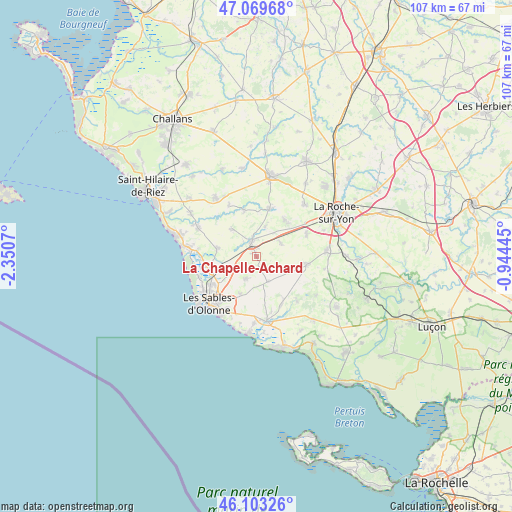
La Chapelle-Achard GPS coordinates[2]
46° 35' 19.032" North, 1° 38' 51.252" West
| Map corner | latitude | longitude |
|---|---|---|
| Upper-left | 47.06968°, | -2.3507° |
| Center: | 46.58862°, | -1.64757° |
| Lower-right: | 46.10326°, | -0.94445° |
| Map W x H: | 107.5×107.5 km | = 66.8×66.8mi |
| max Lat: | 51.07786° ⇑59.3% North |
| La Chapelle-Achard: | 46.58862° |
| min Lat: | ⇓40.7% South 41.3874° |
| min Long | La Chapelle-Ach | max Long |
| -5.08615° | -1.64757° | 9.52242° |
| W 6.8%⇐ | ⇒93.2% E |
Elevation
Elevation of La Chapelle-Achard is 38 m = 125 ft, and this is 155.7 m = 511 ft below average elevation for this country.
| Max E: |
2333 m = 7654 ft | 86.7% |
| Avg. | 193.7 m = 635 ft | |
| La Chapelle-Achard | 38 m = 125 ft | |
Min E: |
-1 m = -3 ft | 13.3% |
See also: France elevation on elevation.city.
Geographical zone
La Chapelle-Achard is located in North temperate zone (between Tropic of Cancer and the Arctic Circle). Distance of this North polar circle is 2221 km =1380.1 mi to North.| Distance of | km | miles | from La Chapelle-Achard |
|---|---|---|---|
| North Pole | 4826.9 | 2999.3 | to North |
| Arctic Circle | 2221 | 1380.1 | to North |
| Tropic Cancer | 2574.2 | 1599.5 | to South |
| Equator | 5180.2 | 3218.8 | to South |


Nearby cities:
15 places around La Chapelle-Achard: (largest is in red/bold)
• Beaulieu-sous-la-Roche
10.2 km =6.3 mi,  15°
15°
• Grosbreuil
6 km =3.7 mi,  156°
156°
• La Mothe-Achard
3.2 km =2 mi,  343°
343°
• Landeronde
9.7 km =6 mi,  38°
38°
• Le Girouard
4.3 km =2.7 mi,  121°
121°
• Les Clouzeaux
11.5 km =7.1 mi,  67°
67°
• Martinet
10 km =6.2 mi,  345°
345°
• Nieul-le-Dolent
10.8 km =6.7 mi,  98°
98°
• Olonne-sur-Mer
11.3 km =7 mi,  238°
238°
• Saint-Georges-de-Pointindoux
6.5 km =4 mi, 17°
• Saint-Julien-des-Landes
7.6 km =4.7 mi,  318°
318°
• Saint-Mathurin
5.7 km =3.5 mi, 242°
• Sainte-Flaive-des-Loups
5.8 km =3.6 mi,  61°
61°
• Sainte-Foy
5.2 km =3.2 mi,  201°
201°
• Vairé
8.4 km =5.2 mi,  279°
279°
Sources, notices
• [Note1] Compared only with cities in France existing in our database
• [Src1] Map data: © OpenStreetMap contributors (CC-BY-SA)
• [Src2] Other city data from geonames.org with taken over terms of usage.
• [Src3] Geographical zone / Annual Mean Temperature by Robert A. Rohde @ Wikipedia
