Vairé geodata
Vairé (Pays de la Loire) is a populated place; located in France in Europe/Paris (GMT+2) time zone. With population of 1,071 people, there are 8327 cities with bigger population in this country. Compared to other cities in France, 59.2% of cities are located further ↑North; 93.8% of cities are located further →East and 80.2% of cities have higher elevation than Vairé. Note1
Administrative division(s):
- Level 1: Pays de la Loire
- Level 2: Département de la Vendée
- Level 3: Arrondissement des Sables-d'Olonne
- Level 4: Vairé


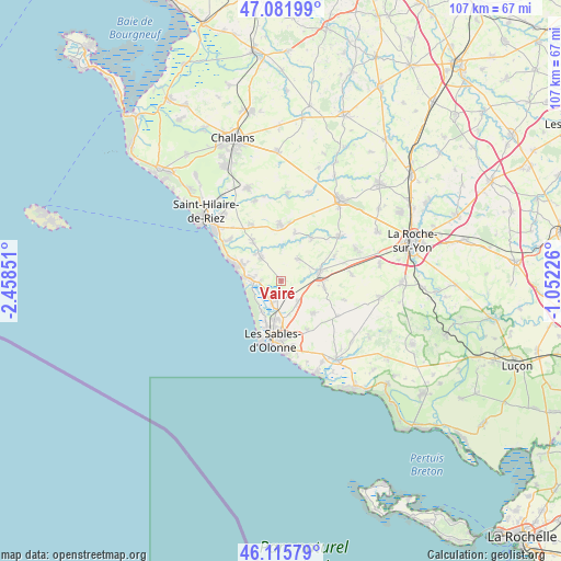
Vairé GPS coordinates[2]
46° 36' 3.744" North, 1° 45' 19.368" West
| Map corner | latitude | longitude |
|---|---|---|
| Upper-left | 47.08199°, | -2.45851° |
| Center: | 46.60104°, | -1.75538° |
| Lower-right: | 46.11579°, | -1.05226° |
| Map W x H: | 107.4×107.4 km | = 66.7×66.7mi |
| max Lat: | 51.07786° ⇑59.2% North |
| Vairé: | 46.60104° |
| min Lat: | ⇓40.8% South 41.3874° |
| min Long | Vairé | max Long |
| -5.08615° | -1.75538° | 9.52242° |
| W 6.2%⇐ | ⇒93.8% E |
Elevation
Elevation of Vairé is 54 m = 177 ft, and this is 139.7 m = 458 ft below average elevation for this country.
| Max E: |
2333 m = 7654 ft | 80.2% |
| Avg. | 193.7 m = 635 ft | |
| Vairé | 54 m = 177 ft | |
Min E: |
-1 m = -3 ft | 19.8% |
See also: France elevation on elevation.city.
Geographical zone
Vairé is located in North temperate zone (between Tropic of Cancer and the Arctic Circle). Distance of this North polar circle is 2219.6 km =1379.2 mi to North.| Distance of | km | miles | from Vairé |
|---|---|---|---|
| North Pole | 4825.5 | 2998.4 | to North |
| Arctic Circle | 2219.6 | 1379.2 | to North |
| Tropic Cancer | 2575.6 | 1600.4 | to South |
| Equator | 5181.5 | 3219.6 | to South |


Nearby cities:
15 places around Vairé: (largest is in red/bold)
• Bretignolles-sur-Mer
9.2 km =5.7 mi,  292°
292°
• Château-d’Olonne
10.9 km =6.8 mi,  174°
174°
• Coëx
10.8 km =6.7 mi,  358°
358°
• La Chaize-Giraud
6.9 km =4.3 mi,  317°
317°
• La Chapelle-Achard
8.4 km =5.2 mi,  99°
99°
• La Chapelle-Hermier
9.4 km =5.8 mi,  15°
15°
• La Mothe-Achard
7.5 km =4.7 mi,  77°
77°
• Landevieille
5.9 km =3.7 mi, 318°
• Les Sables-d’Olonne
11.8 km =7.3 mi,  190°
190°
• Martinet
10 km =6.2 mi,  34°
34°
• Olonne-sur-Mer
7.4 km =4.6 mi, 190°
• Saint-Georges-de-Pointindoux
11.3 km =7 mi,  64°
64°
• Saint-Julien-des-Landes
5.3 km =3.3 mi,  36°
36°
• Saint-Mathurin
5.1 km =3.2 mi,  141°
141°
• Sainte-Foy
8.9 km =5.5 mi,  134°
134°
Sources, notices
• [Note1] Compared only with cities in France existing in our database
• [Src1] Map data: © OpenStreetMap contributors (CC-BY-SA)
• [Src2] Other city data from geonames.org with taken over terms of usage.
• [Src3] Geographical zone / Annual Mean Temperature by Robert A. Rohde @ Wikipedia
