Bugnicourt geodata
Bugnicourt (Hauts-de-France) is a populated place; located in France in Europe/Paris (GMT+2) time zone. With population of 899 people, there are 9669 cities with bigger population in this country. Compared to other cities in France, 95.5% of cities are located further ↓South; 60% of cities are located further ←West and 74.6% of cities have higher elevation than Bugnicourt. Note1
Administrative division(s):
- Level 1: Hauts-de-France
- Level 2: Nord
- Level 3: Arrondissement de Douai
- Level 4: Bugnicourt


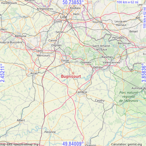
Bugnicourt GPS coordinates[2]
50° 17' 29.148" North, 3° 9' 18.864" East
| Map corner | latitude | longitude |
|---|---|---|
| Upper-left | 50.73853°, | 2.45211° |
| Center: | 50.29143°, | 3.15524° |
| Lower-right: | 49.84009°, | 3.85836° |
| Map W x H: | 99.9×99.9 km | = 62.1×62.1mi |
| max Lat: | 51.07786° ⇑4.5% North |
| Bugnicourt: | 50.29143° |
| min Lat: | ⇓95.5% South 41.3874° |
| min Long | Bugnicourt | max Long |
| -5.08615° | 3.15524° | 9.52242° |
| W 60%⇐ | ⇒40% E |
Elevation
Elevation of Bugnicourt is 68 m = 223 ft, and this is 125.7 m = 412 ft below average elevation for this country.
| Max E: |
2333 m = 7654 ft | 74.6% |
| Avg. | 193.7 m = 635 ft | |
| Bugnicourt | 68 m = 223 ft | |
Min E: |
-1 m = -3 ft | 25.4% |
See also: France elevation on elevation.city.
Geographical zone
Bugnicourt is located in North temperate zone (between Tropic of Cancer and the Arctic Circle). Distance of this North polar circle is 1809.3 km =1124.2 mi to North.| Distance of | km | miles | from Bugnicourt |
|---|---|---|---|
| North Pole | 4415.2 | 2743.5 | to North |
| Arctic Circle | 1809.3 | 1124.2 | to North |
| Tropic Cancer | 2986 | 1855.4 | to South |
| Equator | 5591.9 | 3474.6 | to South |


Nearby cities:
15 places around Bugnicourt: (largest is in red/bold)
• Arleux
3.8 km =2.4 mi,  251°
251°
• Aubencheul-au-Bac
3.9 km =2.4 mi,  177°
177°
• Aubigny-au-Bac
3.2 km =2 mi,  167°
167°
• Cantin
2.8 km =1.7 mi,  314°
314°
• Erchin
3 km =1.9 mi,  15°
15°
• Fressain
2.8 km =1.7 mi,  99°
99°
• Fressies
4.8 km =3 mi,  144°
144°
• Féchain
4.8 km =3 mi,  125°
125°
• Gœulzin
4.8 km =3 mi, 305°
• Lewarde
5.7 km =3.5 mi,  9°
9°
• Marcq-en-Ostrevent
5.9 km =3.7 mi, 96°
• Monchecourt
4.2 km =2.6 mi,  70°
70°
• Oisy-le-Verger
5.1 km =3.2 mi,  206°
206°
• Palluel
5.6 km =3.5 mi,  233°
233°
• Villers-au-Tertre
2.2 km =1.4 mi,  59°
59°
Sources, notices
• [Note1] Compared only with cities in France existing in our database
• [Src1] Map data: © OpenStreetMap contributors (CC-BY-SA)
• [Src2] Other city data from geonames.org with taken over terms of usage.
• [Src3] Geographical zone / Annual Mean Temperature by Robert A. Rohde @ Wikipedia
