Offwiller geodata
Offwiller (Grand Est) is a populated place; located in France in Europe/Paris (GMT+2) time zone. With population of 902 people, there are 9633 cities with bigger population in this country. Compared to other cities in France, 77.8% of cities are located further ↓South; 98.3% of cities are located further ←West and 73.5% of cities have lower elevation than Offwiller. Note1
Administrative division(s):
- Level 1: Grand Est
- Level 2: Bas-Rhin
- Level 3: Arrondissement de Haguenau-Wissembourg
- Level 4: Offwiller


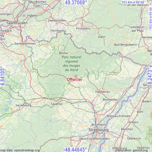
Offwiller GPS coordinates[2]
48° 54' 38.556" North, 7° 32' 39.012" East
| Map corner | latitude | longitude |
|---|---|---|
| Upper-left | 49.37069°, | 6.84105° |
| Center: | 48.91071°, | 7.54417° |
| Lower-right: | 48.44645°, | 8.2473° |
| Map W x H: | 102.8×102.8 km | = 63.9×63.9mi |
| max Lat: | 51.07786° ⇑22.2% North |
| Offwiller: | 48.91071° |
| min Lat: | ⇓77.8% South 41.3874° |
| min Long | Offwiller | max Long |
| -5.08615° | 7.54417° | 9.52242° |
| W 98.3%⇐ | ⇒1.7% E |
Elevation
Elevation of Offwiller is 239 m = 784 ft, and this is 45.3 m = 149 ft above average elevation for this country.
| Max E: |
2333 m = 7654 ft | 26.5% |
| Offwiller | 239 m 784 ft | |
| Avg. | 193.7 m = 635 ft | |
Min E: |
-1 m = -3 ft | 73.5% |
See also: France elevation on elevation.city.
Geographical zone
Offwiller is located in North temperate zone (between Tropic of Cancer and the Arctic Circle). Distance of this North polar circle is 1962.8 km =1219.6 mi to North.| Distance of | km | miles | from Offwiller |
|---|---|---|---|
| North Pole | 4568.7 | 2838.9 | to North |
| Arctic Circle | 1962.8 | 1219.6 | to North |
| Tropic Cancer | 2832.4 | 1760 | to South |
| Equator | 5438.4 | 3379.3 | to South |


Nearby cities:
15 places around Offwiller: (largest is in red/bold)
• Baerenthal
7.4 km =4.6 mi,  345°
345°
• Gumbrechtshoffen
6.2 km =3.9 mi,  95°
95°
• Gundershoffen
8.5 km =5.3 mi,  93°
93°
• Ingwiller
6.3 km =3.9 mi,  228°
228°
• Kindwiller
6.6 km =4.1 mi,  144°
144°
• Lichtenberg
4.7 km =2.9 mi,  285°
285°
• Menchhoffen
6.7 km =4.2 mi,  211°
211°
• Mietesheim
8 km =5 mi,  116°
116°
• Niederbronn-les-Bains
8.5 km =5.3 mi,  57°
57°
• Oberbronn
5.6 km =3.5 mi,  54°
54°
• Obermodern-Zutzendorf
6.8 km =4.2 mi,  186°
186°
• Reipertswiller
6.4 km =4 mi, 293°
• Rothbach
1.2 km =0.7 mi,  251°
251°
• Uhrwiller
4.4 km =2.7 mi,  145°
145°
• Zinswiller
3.5 km =2.2 mi,  73°
73°
Sources, notices
• [Note1] Compared only with cities in France existing in our database
• [Src1] Map data: © OpenStreetMap contributors (CC-BY-SA)
• [Src2] Other city data from geonames.org with taken over terms of usage.
• [Src3] Geographical zone / Annual Mean Temperature by Robert A. Rohde @ Wikipedia
