Oberbronn geodata
Oberbronn (Grand Est) is a populated place; located in France in Europe/Paris (GMT+2) time zone. With population of 1,511 people, there are 6153 cities with bigger population in this country. Compared to other cities in France, 78.4% of cities are located further ↓South; 98.6% of cities are located further ←West and 78% of cities have lower elevation than Oberbronn. Note1
Administrative division(s):
- Level 1: Grand Est
- Level 2: Bas-Rhin
- Level 3: Arrondissement de Haguenau-Wissembourg
- Level 4: Oberbronn


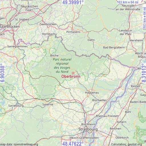
Oberbronn GPS coordinates[2]
48° 56' 24.72" North, 7° 36' 25.2" East
| Map corner | latitude | longitude |
|---|---|---|
| Upper-left | 49.39991°, | 6.90388° |
| Center: | 48.9402°, | 7.607° |
| Lower-right: | 48.47622°, | 8.31013° |
| Map W x H: | 102.7×102.7 km | = 63.8×63.8mi |
| max Lat: | 51.07786° ⇑21.6% North |
| Oberbronn: | 48.9402° |
| min Lat: | ⇓78.4% South 41.3874° |
| min Long | Oberbronn | max Long |
| -5.08615° | 7.607° | 9.52242° |
| W 98.6%⇐ | ⇒1.4% E |
Elevation
Elevation of Oberbronn is 272 m = 892 ft, and this is 78.3 m = 257 ft above average elevation for this country.
| Max E: |
2333 m = 7654 ft | 22% |
| Oberbronn | 272 m 892 ft | |
| Avg. | 193.7 m = 635 ft | |
Min E: |
-1 m = -3 ft | 78% |
See also: France elevation on elevation.city.
Geographical zone
Oberbronn is located in North temperate zone (between Tropic of Cancer and the Arctic Circle). Distance of this North polar circle is 1959.5 km =1217.6 mi to North.| Distance of | km | miles | from Oberbronn |
|---|---|---|---|
| North Pole | 4565.4 | 2836.8 | to North |
| Arctic Circle | 1959.5 | 1217.6 | to North |
| Tropic Cancer | 2835.7 | 1762 | to South |
| Equator | 5441.6 | 3381.3 | to South |


Nearby cities:
15 places around Oberbronn: (largest is in red/bold)
• Baerenthal
7.5 km =4.7 mi,  301°
301°
• Dambach
7.3 km =4.5 mi,  12°
12°
• Forstheim
9.4 km =5.8 mi,  122°
122°
• Frœschwiller
8.1 km =5 mi,  82°
82°
• Gumbrechtshoffen
4.2 km =2.6 mi,  157°
157°
• Gundershoffen
5.4 km =3.4 mi,  133°
133°
• Kindwiller
8.7 km =5.4 mi,  184°
184°
• Lichtenberg
9.4 km =5.8 mi,  257°
257°
• Mietesheim
7.3 km =4.5 mi, 159°
• Niederbronn-les-Bains
2.9 km =1.8 mi,  63°
63°
• Offwiller
5.6 km =3.5 mi,  234°
234°
• Reichshoffen
4.4 km =2.7 mi,  100°
100°
• Rothbach
6.8 km =4.2 mi,  237°
237°
• Uhrwiller
7.2 km =4.5 mi,  197°
197°
• Zinswiller
2.6 km =1.6 mi,  208°
208°
Sources, notices
• [Note1] Compared only with cities in France existing in our database
• [Src1] Map data: © OpenStreetMap contributors (CC-BY-SA)
• [Src2] Other city data from geonames.org with taken over terms of usage.
• [Src3] Geographical zone / Annual Mean Temperature by Robert A. Rohde @ Wikipedia
