Gundershoffen geodata
Gundershoffen (Grand Est) is a populated place; located in France in Europe/Paris (GMT+2) time zone. With population of 3,710 people, there are 2649 cities with bigger population in this country. Compared to other cities in France, 77.7% of cities are located further ↓South; 98.8% of cities are located further ←West and 61% of cities have lower elevation than Gundershoffen. Note1
Administrative division(s):
- Level 1: Grand Est
- Level 2: Bas-Rhin
- Level 3: Arrondissement de Haguenau-Wissembourg
- Level 4: Gundershoffen


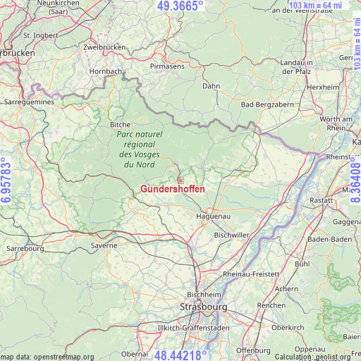
Gundershoffen GPS coordinates[2]
48° 54' 23.328" North, 7° 39' 39.456" East
| Map corner | latitude | longitude |
|---|---|---|
| Upper-left | 49.3665°, | 6.95783° |
| Center: | 48.90648°, | 7.66096° |
| Lower-right: | 48.44218°, | 8.36408° |
| Map W x H: | 102.8×102.8 km | = 63.9×63.9mi |
| max Lat: | 51.07786° ⇑22.3% North |
| Gundershoffen: | 48.90648° |
| min Lat: | ⇓77.7% South 41.3874° |
| min Long | Gundershoffen | max Long |
| -5.08615° | 7.66096° | 9.52242° |
| W 98.8%⇐ | ⇒1.2% E |
Elevation
Elevation of Gundershoffen is 175 m = 574 ft, and this is 18.7 m = 61 ft below average elevation for this country.
| Max E: |
2333 m = 7654 ft | 39% |
| Avg. | 193.7 m = 635 ft | |
| Gundershoffen | 175 m = 574 ft | |
Min E: |
-1 m = -3 ft | 61% |
See also: France elevation on elevation.city.
Geographical zone
Gundershoffen is located in North temperate zone (between Tropic of Cancer and the Arctic Circle). Distance of this North polar circle is 1963.3 km =1219.9 mi to North.| Distance of | km | miles | from Gundershoffen |
|---|---|---|---|
| North Pole | 4569.2 | 2839.2 | to North |
| Arctic Circle | 1963.3 | 1219.9 | to North |
| Tropic Cancer | 2832 | 1759.7 | to South |
| Equator | 5437.9 | 3379 | to South |


Nearby cities:
15 places around Gundershoffen: (largest is in red/bold)
• Eschbach
6.5 km =4 mi,  122°
122°
• Forstheim
4.2 km =2.6 mi,  108°
108°
• Frœschwiller
6.3 km =3.9 mi,  40°
40°
• Gumbrechtshoffen
2.3 km =1.4 mi,  268°
268°
• Kindwiller
6.8 km =4.2 mi,  223°
223°
• Mertzwiller
4.8 km =3 mi,  161°
161°
• Mietesheim
3.4 km =2.1 mi,  204°
204°
• Morsbronn-les-Bains
6.1 km =3.8 mi,  94°
94°
• Niederbronn-les-Bains
5.2 km =3.2 mi,  345°
345°
• Oberbronn
5.4 km =3.4 mi,  313°
313°
• Reichshoffen
3 km =1.9 mi,  6°
6°
• Uberach
6.7 km =4.2 mi, 200°
• Uhrwiller
6.8 km =4.2 mi,  242°
242°
• Woerth
7 km =4.3 mi,  58°
58°
• Zinswiller
5.4 km =3.4 mi,  285°
285°
Sources, notices
• [Note1] Compared only with cities in France existing in our database
• [Src1] Map data: © OpenStreetMap contributors (CC-BY-SA)
• [Src2] Other city data from geonames.org with taken over terms of usage.
• [Src3] Geographical zone / Annual Mean Temperature by Robert A. Rohde @ Wikipedia
