Baerenthal geodata
Baerenthal (Grand Est) is a populated place; located in France in Europe/Paris (GMT+2) time zone. With population of 723 people, there are 11495 cities with bigger population in this country. Compared to other cities in France, 79.1% of cities are located further ↓South; 98.1% of cities are located further ←West and 72.4% of cities have lower elevation than Baerenthal. Note1
Administrative division(s):
- Level 1: Grand Est
- Level 2: Moselle
- Level 3: Arrondissement de Sarreguemines
- Level 4: Baerenthal


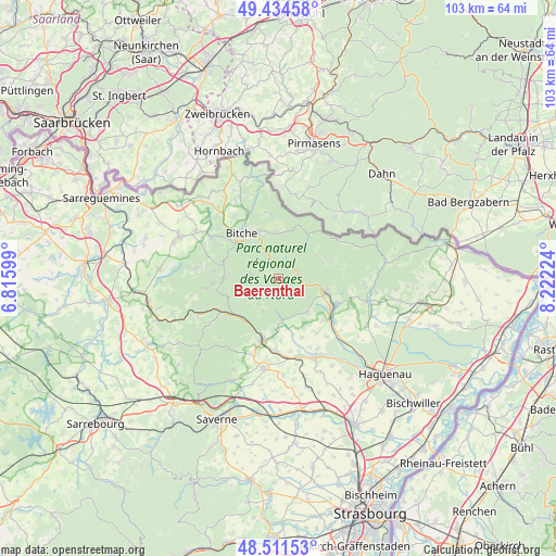
Baerenthal GPS coordinates[2]
48° 58' 30.684" North, 7° 31' 8.796" East
| Map corner | latitude | longitude |
|---|---|---|
| Upper-left | 49.43458°, | 6.81599° |
| Center: | 48.97519°, | 7.51911° |
| Lower-right: | 48.51153°, | 8.22224° |
| Map W x H: | 102.6×102.6 km | = 63.8×63.8mi |
| max Lat: | 51.07786° ⇑20.9% North |
| Baerenthal: | 48.97519° |
| min Lat: | ⇓79.1% South 41.3874° |
| min Long | Baerenthal | max Long |
| -5.08615° | 7.51911° | 9.52242° |
| W 98.1%⇐ | ⇒1.9% E |
Elevation
Elevation of Baerenthal is 232 m = 761 ft, and this is 38.3 m = 126 ft above average elevation for this country.
| Max E: |
2333 m = 7654 ft | 27.6% |
| Baerenthal | 232 m 761 ft | |
| Avg. | 193.7 m = 635 ft | |
Min E: |
-1 m = -3 ft | 72.4% |
See also: France elevation on elevation.city.
Geographical zone
Baerenthal is located in North temperate zone (between Tropic of Cancer and the Arctic Circle). Distance of this North polar circle is 1955.6 km =1215.2 mi to North.| Distance of | km | miles | from Baerenthal |
|---|---|---|---|
| North Pole | 4561.5 | 2834.4 | to North |
| Arctic Circle | 1955.6 | 1215.2 | to North |
| Tropic Cancer | 2839.6 | 1764.4 | to South |
| Equator | 5445.5 | 3383.7 | to South |


Nearby cities:
15 places around Baerenthal: (largest is in red/bold)
• Bitche
10.8 km =6.7 mi,  322°
322°
• Dambach
8.6 km =5.3 mi,  67°
67°
• Goetzenbruck
10.2 km =6.3 mi,  271°
271°
• Gumbrechtshoffen
11.1 km =6.9 mi,  133°
133°
• Lemberg
10.7 km =6.6 mi,  286°
286°
• Lichtenberg
6.5 km =4 mi,  204°
204°
• Niederbronn-les-Bains
9.4 km =5.8 mi,  106°
106°
• Oberbronn
7.5 km =4.7 mi,  121°
121°
• Offwiller
7.4 km =4.6 mi,  165°
165°
• Reichshoffen
11.7 km =7.3 mi, 113°
• Reipertswiller
6.2 km =3.9 mi,  220°
220°
• Rothbach
7.6 km =4.7 mi, 174°
• Uhrwiller
11.6 km =7.2 mi,  158°
158°
• Wimmenau
10 km =6.2 mi,  225°
225°
• Zinswiller
8 km =5 mi,  140°
140°
Sources, notices
• [Note1] Compared only with cities in France existing in our database
• [Src1] Map data: © OpenStreetMap contributors (CC-BY-SA)
• [Src2] Other city data from geonames.org with taken over terms of usage.
• [Src3] Geographical zone / Annual Mean Temperature by Robert A. Rohde @ Wikipedia
