Nyons geodata
Nyons (Auvergne-Rhône-Alpes) is a seat of a third-order administrative division; located in France in Europe/Paris (GMT+2) time zone. With population of 7,330 people, there are 1332 cities with bigger population in this country. Compared to other cities in France, 84.5% of cities are located further ↑North; 79.1% of cities are located further ←West and 81% of cities have lower elevation than Nyons. Note1
Administrative division(s):
- Level 1: Auvergne-Rhône-Alpes
- Level 2: Département de la Drôme
- Level 3: Arrondissement de Nyons
- Level 4: Nyons


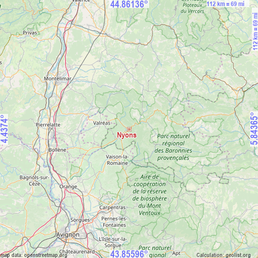
Nyons GPS coordinates[2]
44° 21' 38.952" North, 5° 8' 25.872" East
| Map corner | latitude | longitude |
|---|---|---|
| Upper-left | 44.86136°, | 4.4374° |
| Center: | 44.36082°, | 5.14052° |
| Lower-right: | 43.85596°, | 5.84365° |
| Map W x H: | 111.8×111.8 km | = 69.5×69.5mi |
| max Lat: | 51.07786° ⇑84.5% North |
| Nyons: | 44.36082° |
| min Lat: | ⇓15.5% South 41.3874° |
| min Long | Nyons | max Long |
| -5.08615° | 5.14052° | 9.52242° |
| W 79.1%⇐ | ⇒20.9% E |
Elevation
Elevation of Nyons is 300 m = 984 ft, and this is 106.3 m = 349 ft above average elevation for this country.
| Max E: |
2333 m = 7654 ft | 19% |
| Nyons | 300 m 984 ft | |
| Avg. | 193.7 m = 635 ft | |
Min E: |
-1 m = -3 ft | 81% |
See also: France elevation on elevation.city.
Geographical zone
Nyons is located in North temperate zone (between Tropic of Cancer and the Arctic Circle). Distance of this Northern Tropic circle is 2326.5 km =1445.6 mi to South.| Distance of | km | miles | from Nyons |
|---|---|---|---|
| North Pole | 5074.6 | 3153.2 | to North |
| Arctic Circle | 2468.7 | 1534 | to North |
| Tropic Cancer | 2326.5 | 1445.6 | to South |
| Equator | 4932.5 | 3064.9 | to South |


Nearby cities:
15 places around Nyons: (largest is in red/bold)
• Buis-les-Baronnies
14 km =8.7 mi,  131°
131°
• Condorcet
7 km =4.3 mi,  42°
42°
• Entrechaux
15.9 km =9.9 mi,  180°
180°
• Mirabel-aux-Baronnies
6.5 km =4 mi,  209°
209°
• Mollans-sur-Ouvèze
14.3 km =8.9 mi,  164°
164°
• Puyméras
10.1 km =6.3 mi,  185°
185°
• Roaix
16.2 km =10.1 mi,  217°
217°
• Saint-Maurice-sur-Eygues
12.4 km =7.7 mi,  236°
236°
• Saint-Romain-en-Viennois
11.7 km =7.3 mi, 192°
• Vaison-la-Romaine
14.5 km =9 mi,  201°
201°
• Valréas
12.2 km =7.6 mi,  282°
282°
• Venterol
4.4 km =2.7 mi,  314°
314°
• Villedieu
12 km =7.5 mi, 224°
• Vinsobres
7 km =4.3 mi, 243°
• Visan
16 km =9.9 mi,  251°
251°
Sources, notices
• [Note1] Compared only with cities in France existing in our database
• [Src1] Map data: © OpenStreetMap contributors (CC-BY-SA)
• [Src2] Other city data from geonames.org with taken over terms of usage.
• [Src3] Geographical zone / Annual Mean Temperature by Robert A. Rohde @ Wikipedia
