Villedieu geodata
Villedieu (Provence-Alpes-Côte d'Azur) is a populated place; located in France in Europe/Paris (GMT+2) time zone. With population of 546 people, there are 14284 cities with bigger population in this country. Compared to other cities in France, 84.9% of cities are located further ↑North; 78% of cities are located further ←West and 75.8% of cities have lower elevation than Villedieu. Note1
Administrative division(s):
- Level 1: Provence-Alpes-Côte d'Azur
- Level 2: Département du Vaucluse
- Level 3: Arrondissement de Carpentras
- Level 4: Villedieu


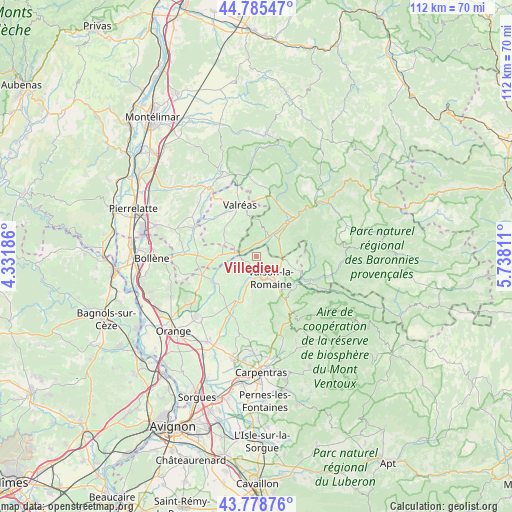
Villedieu GPS coordinates[2]
44° 17' 3.372" North, 5° 2' 5.964" East
| Map corner | latitude | longitude |
|---|---|---|
| Upper-left | 44.78547°, | 4.33186° |
| Center: | 44.28427°, | 5.03499° |
| Lower-right: | 43.77876°, | 5.73811° |
| Map W x H: | 111.9×111.9 km | = 69.5×69.5mi |
| max Lat: | 51.07786° ⇑84.9% North |
| Villedieu: | 44.28427° |
| min Lat: | ⇓15.1% South 41.3874° |
| min Long | Villedieu | max Long |
| -5.08615° | 5.03499° | 9.52242° |
| W 78%⇐ | ⇒22% E |
Elevation
Elevation of Villedieu is 255 m = 837 ft, and this is 61.3 m = 201 ft above average elevation for this country.
| Max E: |
2333 m = 7654 ft | 24.2% |
| Villedieu | 255 m 837 ft | |
| Avg. | 193.7 m = 635 ft | |
Min E: |
-1 m = -3 ft | 75.8% |
See also: France elevation on elevation.city.
Geographical zone
Villedieu is located in North temperate zone (between Tropic of Cancer and the Arctic Circle). Distance of this Northern Tropic circle is 2318 km =1440.3 mi to South.| Distance of | km | miles | from Villedieu |
|---|---|---|---|
| North Pole | 5083.1 | 3158.5 | to North |
| Arctic Circle | 2477.2 | 1539.3 | to North |
| Tropic Cancer | 2318 | 1440.3 | to South |
| Equator | 4923.9 | 3059.6 | to South |


Nearby cities:
15 places around Villedieu: (largest is in red/bold)
• Cairanne
9.9 km =6.2 mi,  235°
235°
• Entrechaux
11 km =6.8 mi,  132°
132°
• Mirabel-aux-Baronnies
5.9 km =3.7 mi,  60°
60°
• Puyméras
7.6 km =4.7 mi,  101°
101°
• Rasteau
7.1 km =4.4 mi,  212°
212°
• Roaix
4.5 km =2.8 mi,  198°
198°
• Sablet
10.5 km =6.5 mi,  192°
192°
• Saint-Maurice-sur-Eygues
2.6 km =1.6 mi,  311°
311°
• Saint-Romain-en-Viennois
6.6 km =4.1 mi,  116°
116°
• Séguret
8.8 km =5.5 mi, 186°
• Tulette
8.3 km =5.2 mi,  271°
271°
• Vaison-la-Romaine
5.9 km =3.7 mi,  147°
147°
• Valréas
11.7 km =7.3 mi,  342°
342°
• Vinsobres
5.9 km =3.7 mi,  21°
21°
• Visan
7.5 km =4.7 mi,  296°
296°
Sources, notices
• [Note1] Compared only with cities in France existing in our database
• [Src1] Map data: © OpenStreetMap contributors (CC-BY-SA)
• [Src2] Other city data from geonames.org with taken over terms of usage.
• [Src3] Geographical zone / Annual Mean Temperature by Robert A. Rohde @ Wikipedia
