Entrechaux geodata
Entrechaux (Provence-Alpes-Côte d'Azur) is a populated place; located in France in Europe/Paris (GMT+2) time zone. With population of 925 people, there are 9431 cities with bigger population in this country. Compared to other cities in France, 85.4% of cities are located further ↑North; 79.1% of cities are located further ←West and 81% of cities have lower elevation than Entrechaux. Note1
Administrative division(s):
- Level 1: Provence-Alpes-Côte d'Azur
- Level 2: Département du Vaucluse
- Level 3: Arrondissement de Carpentras
- Level 4: Entrechaux


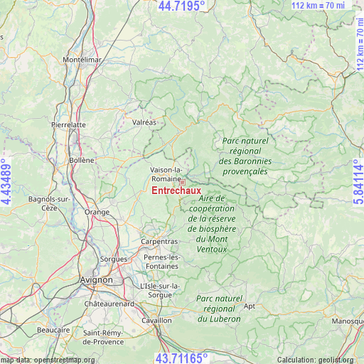
Entrechaux GPS coordinates[2]
44° 13' 3.828" North, 5° 8' 16.836" East
| Map corner | latitude | longitude |
|---|---|---|
| Upper-left | 44.7195°, | 4.43489° |
| Center: | 44.21773°, | 5.13801° |
| Lower-right: | 43.71165°, | 5.84114° |
| Map W x H: | 112.1×112.1 km | = 69.7×69.7mi |
| max Lat: | 51.07786° ⇑85.4% North |
| Entrechaux: | 44.21773° |
| min Lat: | ⇓14.6% South 41.3874° |
| min Long | Entrechaux | max Long |
| -5.08615° | 5.13801° | 9.52242° |
| W 79.1%⇐ | ⇒20.9% E |
Elevation
Elevation of Entrechaux is 300 m = 984 ft, and this is 106.3 m = 349 ft above average elevation for this country.
| Max E: |
2333 m = 7654 ft | 19% |
| Entrechaux | 300 m 984 ft | |
| Avg. | 193.7 m = 635 ft | |
Min E: |
-1 m = -3 ft | 81% |
See also: France elevation on elevation.city.
Geographical zone
Entrechaux is located in North temperate zone (between Tropic of Cancer and the Arctic Circle). Distance of this Northern Tropic circle is 2310.6 km =1435.7 mi to South.| Distance of | km | miles | from Entrechaux |
|---|---|---|---|
| North Pole | 5090.5 | 3163.1 | to North |
| Arctic Circle | 2484.6 | 1543.9 | to North |
| Tropic Cancer | 2310.6 | 1435.7 | to South |
| Equator | 4916.6 | 3055 | to South |


Nearby cities:
15 places around Entrechaux: (largest is in red/bold)
• Bédoin
10.9 km =6.8 mi,  161°
161°
• Caromb
12.1 km =7.5 mi,  191°
191°
• Gigondas
12.2 km =7.6 mi,  240°
240°
• Le Barroux
9.6 km =6 mi,  198°
198°
• Malaucène
4.9 km =3 mi, 185°
• Mirabel-aux-Baronnies
10.7 km =6.6 mi,  343°
343°
• Mollans-sur-Ouvèze
4.6 km =2.9 mi,  62°
62°
• Puyméras
5.9 km =3.7 mi,  352°
352°
• Rasteau
12.1 km =7.5 mi,  276°
276°
• Roaix
10.1 km =6.3 mi,  287°
287°
• Sablet
10.9 km =6.8 mi,  255°
255°
• Saint-Romain-en-Viennois
5 km =3.1 mi,  333°
333°
• Séguret
9.3 km =5.8 mi, 261°
• Vaison-la-Romaine
5.6 km =3.5 mi,  295°
295°
• Villedieu
11 km =6.8 mi,  312°
312°
Sources, notices
• [Note1] Compared only with cities in France existing in our database
• [Src1] Map data: © OpenStreetMap contributors (CC-BY-SA)
• [Src2] Other city data from geonames.org with taken over terms of usage.
• [Src3] Geographical zone / Annual Mean Temperature by Robert A. Rohde @ Wikipedia
