Noyers-Saint-Martin geodata
Noyers-Saint-Martin (Hauts-de-France) is a populated place; located in France in Europe/Paris (GMT+2) time zone. With population of 745 people, there are 11223 cities with bigger population in this country. Compared to other cities in France, 90% of cities are located further ↓South; 53.3% of cities are located further →East and 60% of cities have lower elevation than Noyers-Saint-Martin. Note1
Administrative division(s):
- Level 1: Hauts-de-France
- Level 2: Département de l'Oise
- Level 3: Arrondissement de Clermont
- Level 4: Noyers-Saint-Martin


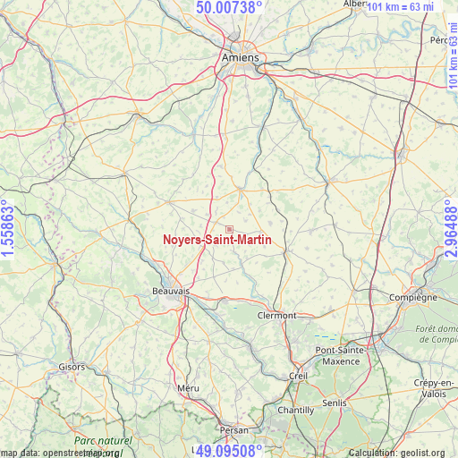
Noyers-Saint-Martin GPS coordinates[2]
49° 33' 12.096" North, 2° 15' 42.3" East
| Map corner | latitude | longitude |
|---|---|---|
| Upper-left | 50.00738°, | 1.55863° |
| Center: | 49.55336°, | 2.26175° |
| Lower-right: | 49.09508°, | 2.96488° |
| Map W x H: | 101.4×101.4 km | = 63×63mi |
| max Lat: | 51.07786° ⇑10% North |
| Noyers-Saint-Martin: | 49.55336° |
| min Lat: | ⇓90% South 41.3874° |
| min Long | Noyers-Saint-Ma | max Long |
| -5.08615° | 2.26175° | 9.52242° |
| W 46.7%⇐ | ⇒53.3% E |
Elevation
Elevation of Noyers-Saint-Martin is 170 m = 558 ft, and this is 23.7 m = 78 ft below average elevation for this country.
| Max E: |
2333 m = 7654 ft | 40% |
| Avg. | 193.7 m = 635 ft | |
| Noyers-Saint-Martin | 170 m = 558 ft | |
Min E: |
-1 m = -3 ft | 60% |
See also: France elevation on elevation.city.
Geographical zone
Noyers-Saint-Martin is located in North temperate zone (between Tropic of Cancer and the Arctic Circle). Distance of this North polar circle is 1891.4 km =1175.3 mi to North.| Distance of | km | miles | from Noyers-Saint-Martin |
|---|---|---|---|
| North Pole | 4497.2 | 2794.4 | to North |
| Arctic Circle | 1891.4 | 1175.3 | to North |
| Tropic Cancer | 2903.9 | 1804.4 | to South |
| Equator | 5509.8 | 3423.6 | to South |


Nearby cities:
15 places around Noyers-Saint-Martin: (largest is in red/bold)
• Abbeville-Saint-Lucien
7.8 km =4.8 mi,  238°
238°
• Ansauvillers
9.2 km =5.7 mi,  81°
81°
• Breteuil
9.2 km =5.7 mi,  15°
15°
• Bulles
11.4 km =7.1 mi,  156°
156°
• Catillon-Fumechon
8.6 km =5.3 mi,  118°
118°
• Esquennoy
11.6 km =7.2 mi,  2°
2°
• Fournival
13 km =8.1 mi,  137°
137°
• Froissy
3.3 km =2.1 mi,  299°
299°
• Hardivillers
7.6 km =4.7 mi,  338°
338°
• Haudivillers
7.4 km =4.6 mi,  190°
190°
• Luchy
10.3 km =6.4 mi,  270°
270°
• Oroër
9.6 km =6 mi,  228°
228°
• Saint-André-Farivillers
4.3 km =2.7 mi,  29°
29°
• Verderel-lès-Sauqueuse
13.1 km =8.1 mi, 243°
• Wavignies
7.1 km =4.4 mi,  95°
95°
Sources, notices
• [Note1] Compared only with cities in France existing in our database
• [Src1] Map data: © OpenStreetMap contributors (CC-BY-SA)
• [Src2] Other city data from geonames.org with taken over terms of usage.
• [Src3] Geographical zone / Annual Mean Temperature by Robert A. Rohde @ Wikipedia
