Charmes geodata
Charmes (Grand Est) is a populated place; located in France in Europe/Paris (GMT+2) time zone. With population of 4,825 people, there are 2054 cities with bigger population in this country. Compared to other cities in France, 65.9% of cities are located further ↓South; 90.1% of cities are located further ←West and 79.2% of cities have lower elevation than Charmes. Note1
Administrative division(s):
- Level 1: Grand Est
- Level 2: Vosges
- Level 3: Arrondissement d’Épinal
- Level 4: Charmes


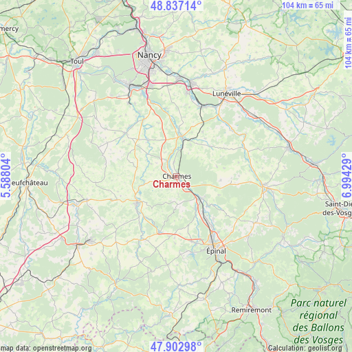
Charmes GPS coordinates[2]
48° 22' 19.92" North, 6° 17' 28.212" East
| Map corner | latitude | longitude |
|---|---|---|
| Upper-left | 48.83714°, | 5.58804° |
| Center: | 48.3722°, | 6.29117° |
| Lower-right: | 47.90298°, | 6.99429° |
| Map W x H: | 103.9×103.9 km | = 64.6×64.6mi |
| max Lat: | 51.07786° ⇑34.1% North |
| Charmes: | 48.3722° |
| min Lat: | ⇓65.9% South 41.3874° |
| min Long | Charmes | max Long |
| -5.08615° | 6.29117° | 9.52242° |
| W 90.1%⇐ | ⇒9.9% E |
Elevation
Elevation of Charmes is 282 m = 925 ft, and this is 88.3 m = 290 ft above average elevation for this country.
| Max E: |
2333 m = 7654 ft | 20.8% |
| Charmes | 282 m 925 ft | |
| Avg. | 193.7 m = 635 ft | |
Min E: |
-1 m = -3 ft | 79.2% |
See also: France elevation on elevation.city.
Geographical zone
Charmes is located in North temperate zone (between Tropic of Cancer and the Arctic Circle). Distance of this North polar circle is 2022.7 km =1256.8 mi to North.| Distance of | km | miles | from Charmes |
|---|---|---|---|
| North Pole | 4628.6 | 2876.1 | to North |
| Arctic Circle | 2022.7 | 1256.8 | to North |
| Tropic Cancer | 2772.6 | 1722.8 | to South |
| Equator | 5378.5 | 3342 | to South |


Nearby cities:
15 places around Charmes: (largest is in red/bold)
• Bayon
11.5 km =7.1 mi,  9°
9°
• Benney
16.6 km =10.3 mi,  341°
341°
• Châtel-sur-Moselle
10 km =6.2 mi,  130°
130°
• Essegney
2 km =1.2 mi,  104°
104°
• Hymont
16.1 km =10 mi,  223°
223°
• Igney
13.5 km =8.4 mi,  144°
144°
• Mattaincourt
15.6 km =9.7 mi,  229°
229°
• Mirecourt
14.1 km =8.8 mi,  235°
235°
• Nomexy
10 km =6.2 mi, 135°
• Portieux
5 km =3.1 mi, 127°
• Poussay
13.7 km =8.5 mi, 244°
• Roville-devant-Bayon
10.5 km =6.5 mi,  0°
0°
• Tantonville
15.7 km =9.8 mi,  313°
313°
• Thaon-les-Vosges
16.5 km =10.3 mi,  145°
145°
• Vincey
4.9 km =3 mi, 142°
Sources, notices
• [Note1] Compared only with cities in France existing in our database
• [Src1] Map data: © OpenStreetMap contributors (CC-BY-SA)
• [Src2] Other city data from geonames.org with taken over terms of usage.
• [Src3] Geographical zone / Annual Mean Temperature by Robert A. Rohde @ Wikipedia
