Nattages geodata
Nattages (Auvergne-Rhône-Alpes) is a populated place; located in France in Europe/Paris (GMT+2) time zone. With population of 506 people, there are 15128 cities with bigger population in this country. Compared to other cities in France, 70.4% of cities are located further ↑North; 84.8% of cities are located further ←West and 81.9% of cities have lower elevation than Nattages. Note1
Administrative division(s):
- Level 1: Auvergne-Rhône-Alpes
- Level 2: Département de l'Ain
- Level 3: Arrondissement de Belley
- Level 4: Parves et Nattages


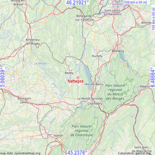
Nattages GPS coordinates[2]
45° 43' 50.016" North, 5° 45' 48.636" East
| Map corner | latitude | longitude |
|---|---|---|
| Upper-left | 46.21921°, | 5.06039° |
| Center: | 45.73056°, | 5.76351° |
| Lower-right: | 45.2376°, | 6.46664° |
| Map W x H: | 109.1×109.1 km | = 67.8×67.8mi |
| max Lat: | 51.07786° ⇑70.4% North |
| Nattages: | 45.73056° |
| min Lat: | ⇓29.6% South 41.3874° |
| min Long | Nattages | max Long |
| -5.08615° | 5.76351° | 9.52242° |
| W 84.8%⇐ | ⇒15.2% E |
Elevation
Elevation of Nattages is 310 m = 1017 ft, and this is 116.3 m = 382 ft above average elevation for this country.
| Max E: |
2333 m = 7654 ft | 18.1% |
| Nattages | 310 m 1017 ft | |
| Avg. | 193.7 m = 635 ft | |
Min E: |
-1 m = -3 ft | 81.9% |
See also: France elevation on elevation.city.
Geographical zone
Nattages is located in North temperate zone (between Tropic of Cancer and the Arctic Circle). Distance of this North polar circle is 2316.4 km =1439.3 mi to North.| Distance of | km | miles | from Nattages |
|---|---|---|---|
| North Pole | 4922.3 | 3058.6 | to North |
| Arctic Circle | 2316.4 | 1439.3 | to North |
| Tropic Cancer | 2478.8 | 1540.3 | to South |
| Equator | 5084.8 | 3159.5 | to South |


Nearby cities:
15 places around Nattages: (largest is in red/bold)
• Aix-les-Bains
12.1 km =7.5 mi,  110°
110°
• Belley
6.7 km =4.2 mi,  298°
298°
• Brens
5.6 km =3.5 mi,  269°
269°
• Brison-Saint-Innocent
9.8 km =6.1 mi,  94°
94°
• Ceyzérieu
12 km =7.5 mi,  346°
346°
• Chanaz
9 km =5.6 mi,  15°
15°
• Chazey-Bons
10.3 km =6.4 mi,  322°
322°
• Chindrieux
12 km =7.5 mi,  34°
34°
• Châtillon
10 km =6.2 mi,  38°
38°
• Le Bourget-du-Lac
11.1 km =6.9 mi,  140°
140°
• Massignieu-de-Rives
2.7 km =1.7 mi,  4°
4°
• Saint-Jean-de-Chevelu
6.4 km =4 mi,  125°
125°
• Tresserve
12.1 km =7.5 mi,  119°
119°
• Virignin
4.2 km =2.6 mi,  251°
251°
• Yenne
3 km =1.9 mi,  188°
188°
Sources, notices
• [Note1] Compared only with cities in France existing in our database
• [Src1] Map data: © OpenStreetMap contributors (CC-BY-SA)
• [Src2] Other city data from geonames.org with taken over terms of usage.
• [Src3] Geographical zone / Annual Mean Temperature by Robert A. Rohde @ Wikipedia
