Ceyzérieu geodata
Ceyzérieu (Auvergne-Rhône-Alpes) is a populated place; located in France in Europe/Paris (GMT+2) time zone. With population of 889 people, there are 9749 cities with bigger population in this country. Compared to other cities in France, 68.7% of cities are located further ↑North; 84.5% of cities are located further ←West and 77.9% of cities have lower elevation than Ceyzérieu. Note1
Administrative division(s):
- Level 1: Auvergne-Rhône-Alpes
- Level 2: Département de l'Ain
- Level 3: Arrondissement de Belley
- Level 4: Ceyzérieu


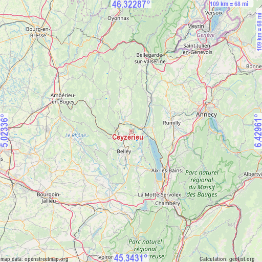
Ceyzérieu GPS coordinates[2]
45° 50' 6.504" North, 5° 43' 35.364" East
| Map corner | latitude | longitude |
|---|---|---|
| Upper-left | 46.32287°, | 5.02336° |
| Center: | 45.83514°, | 5.72649° |
| Lower-right: | 45.3431°, | 6.42961° |
| Map W x H: | 108.9×108.9 km | = 67.7×67.7mi |
| max Lat: | 51.07786° ⇑68.7% North |
| Ceyzérieu: | 45.83514° |
| min Lat: | ⇓31.3% South 41.3874° |
| min Long | Ceyzérieu | max Long |
| -5.08615° | 5.72649° | 9.52242° |
| W 84.5%⇐ | ⇒15.5% E |
Elevation
Elevation of Ceyzérieu is 271 m = 889 ft, and this is 77.3 m = 254 ft above average elevation for this country.
| Max E: |
2333 m = 7654 ft | 22.1% |
| Ceyzérieu | 271 m 889 ft | |
| Avg. | 193.7 m = 635 ft | |
Min E: |
-1 m = -3 ft | 77.9% |
See also: France elevation on elevation.city.
Geographical zone
Ceyzérieu is located in North temperate zone (between Tropic of Cancer and the Arctic Circle). Distance of this North polar circle is 2304.8 km =1432.1 mi to North.| Distance of | km | miles | from Ceyzérieu |
|---|---|---|---|
| North Pole | 4910.7 | 3051.4 | to North |
| Arctic Circle | 2304.8 | 1432.1 | to North |
| Tropic Cancer | 2490.5 | 1547.5 | to South |
| Equator | 5096.4 | 3166.8 | to South |


Nearby cities:
15 places around Ceyzérieu: (largest is in red/bold)
• Anglefort
10.6 km =6.6 mi,  36°
36°
• Artemare
5.1 km =3.2 mi,  329°
329°
• Belley
9 km =5.6 mi,  199°
199°
• Brens
12 km =7.5 mi,  193°
193°
• Chanaz
6 km =3.7 mi,  119°
119°
• Chazey-Bons
4.9 km =3 mi,  224°
224°
• Chindrieux
9.7 km =6 mi,  100°
100°
• Châtillon
9.8 km =6.1 mi,  112°
112°
• Culoz
4.8 km =3 mi,  71°
71°
• Massignieu-de-Rives
9.5 km =5.9 mi,  160°
160°
• Nattages
12 km =7.5 mi,  166°
166°
• Ruffieux
9.2 km =5.7 mi,  80°
80°
• Serrières-en-Chautagne
10.4 km =6.5 mi,  60°
60°
• Virieu-le-Grand
6 km =3.7 mi,  283°
283°
• Virignin
13 km =8.1 mi,  184°
184°
Sources, notices
• [Note1] Compared only with cities in France existing in our database
• [Src1] Map data: © OpenStreetMap contributors (CC-BY-SA)
• [Src2] Other city data from geonames.org with taken over terms of usage.
• [Src3] Geographical zone / Annual Mean Temperature by Robert A. Rohde @ Wikipedia
